


If you’re dipping your turkey into a pot of boiling oil – you may have to shovel off a spot.
That’s according to the latest from the National Weather Service – which has issued a Winter Storm Warning for much of Minnesota, including all of Wright County.
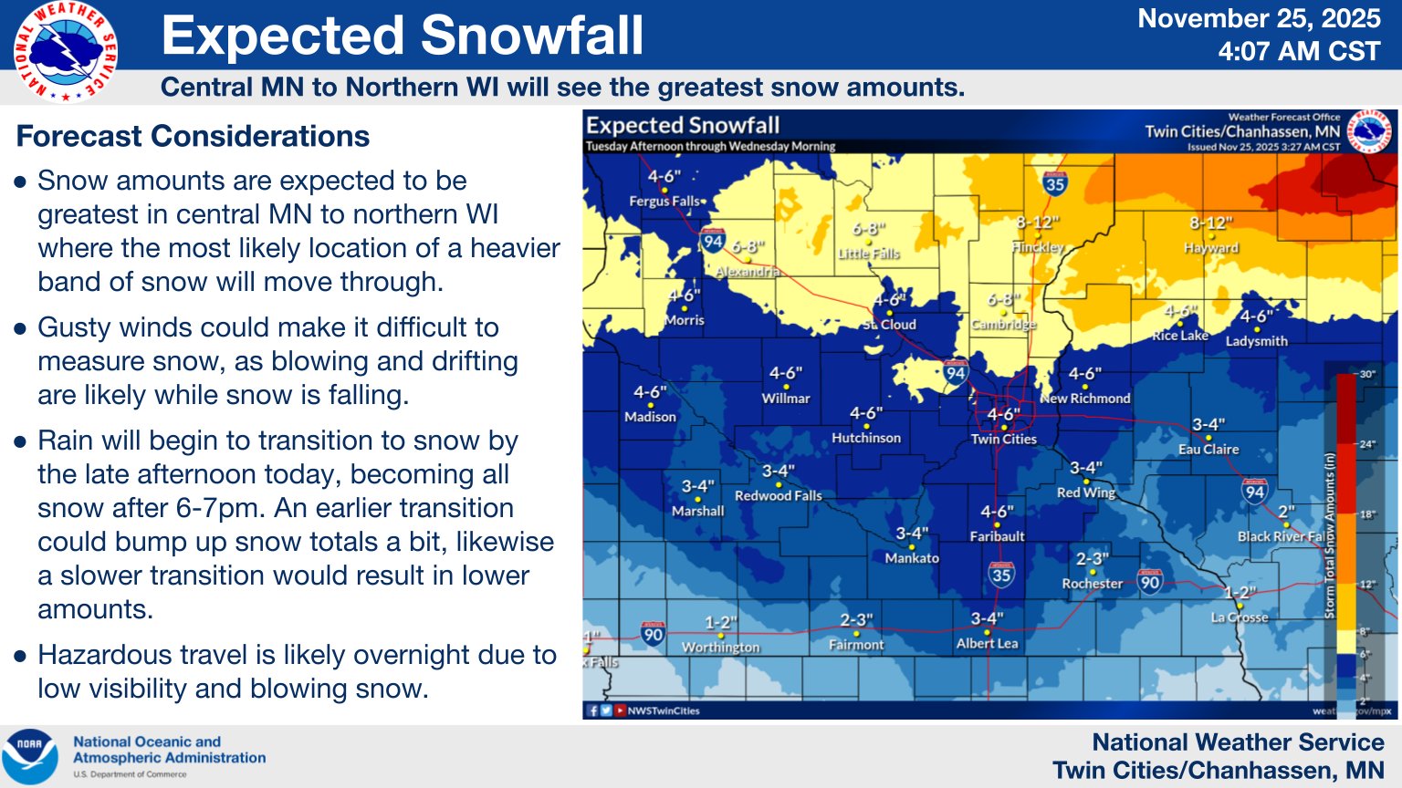
While the storm is still expected to have its greatest impact in northern Minnesota – a line from Alexandria west to Hayward, Wisconsin and then north to the North Shore – Wright County could still see “plowable” snow amounts of 3-6 inches.
Here’s the latest Warning from NWS:
URGENT - WINTER WEATHER MESSAGE
National Weather Service Twin Cities/Chanhassen MN
625 AM CST Tue Nov 25 2025

...RAIN WILL TURN TO HEAVY SNOW FROM WEST TO EAST THIS AFTERNOON AND
TONIGHT...
...SNOWFALL RATES EXCEEDING AN INCH PER HOUR AND STRONG NORTHWEST
WINDS GUSTING TO 45 MPH MAY LEAD TO BLIZZARD CONDITIONS AT TIMES...

.A potent storm system will move across the area today and tonight.
Rain will transition snow from west to east as cold air arrives.
Periods of heavy snow are expected with rates of around an inch per
hour at times. The heaviest totals will be found across central
Minnesota and northwest Wisconsin where around 6 inches are expected.
Farther south across southern Minnesota and parts of west central
Wisconsin, 1 to 3 inches are expected.

Winds will increase later today and tonight with gusts as high as 45
mph. Combined with the falling snow, widespread blowing snow and
blizzard conditions are possible at times with visibilities 1/4 mile
or less.

The Winter Storm
Warning remains in effect for central and most of
southern Minnesota and northwest Wisconsin. A Winter Weather Advisory
is in effect for far southern Minnesota and parts of west central
Wisconsin.

MNZ051>053-059>061-066>069-074>076-082-083-WIZ014-260030-
/O.CON.KMPX.WS.W.0006.251126T0000Z-251126T1500Z/
Sherburne-Isanti-Chisago-Wright-Hennepin-Anoka-McLeod-Sibley-Carver-
Scott-Brown-Nicollet-Le Sueur-Watonwan-Blue Earth-Polk-
Including the cities of Shakopee, Minneapolis, Chaska, Hutchinson,
Monticello, Center City, St Peter, Osceola, Chanhassen, Victoria, New
Ulm, St James, Le Sueur, Mankato, Blaine, Cambridge, Gaylord, and Elk
River
625 AM CST Tue Nov 25 2025

...WINTER STORM WARNING REMAINS IN EFFECT FROM 6 PM THIS EVENING TO 9
AM CST WEDNESDAY...

* WHAT...Heavy snow and blowing snow expected. Total snow
  accumulations of 2 to 4 inches across southern Minnesota, to 4 to 7
  inches across central Minnesota and northwest Wisconsin. Winds
  gusting as high as 45 mph.

* WHERE...Portions of central, east central, and south central
  Minnesota and northwest Wisconsin.

* WHEN...From 6 PM this evening to 9 AM CST Wednesday.

* IMPACTS...Travel could be very difficult. The hazardous conditions
  will impact the Tuesday evening and Wednesday morning commutes.
  Gusty winds could bring down tree branches.