


A major storm front pushing its way out of the Colorado Rockies last night and through the upper portions of the Great Plains today is expected to make its way into Minnesota this afternoon, and the results may not be pretty.
The cold front is expected to carry high winds, some possibly damaging, and heavy rainfall, starting as early as dinner time tonight.
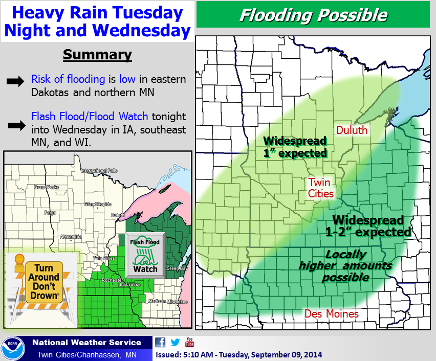
Behind this wave of unpleasant weather is even more rain. The National Weather Service in Chanhassen, which serves the Twin Cities, is saying the Wright County area could see 1 to 2 inches of rain or more over the next 24 hours, or as much as the area typically gets for the majority of the month of September in one night.
The system is being fueled by both a cold front sweeping the upper third of the country, along with remnants of Hurricane Norbert, which dumped huge amounts of rain on Phoenix over the past three days and is now tracking northeast through Nebraska and Iowa, as well as feeding this system.
After the rain, the bottom drops out as summer is escorted out of the area with fall temperatures. Though the season doesn’t officially start for another two weeks, temperatures this week will hover in the 50s for Wednesday, Thursday and Friday, before barely climbing back into the 60s for the weekend.

The low Friday night is going to bottom out near freezing, forecasters predict, with some snow (what?) possible in the northern parts of Minnesota as another weather system crosses the state Friday night.
In contrast, the average temperature for the North Wright County area this week is about 68 degrees for the high, with a low of around
Homecoming week for St. Michael-Albertville is looking quite a bit nicer. Temperatures will be in the upper 60s, with a good chance for rain again next Wednesday night.
Here’s the “Special Weather Statement” from the NWS:
THIS HAZARDOUS WEATHER OUTLOOK IS FOR PORTIONS OF CENTRAL AND SOUTHERN MINNESOTA… AND WEST CENTRAL WISCONSIN. .DAY ONE…THIS AFTERNOON AND TONIGHT
THERE IS A SLIGHT RISK OF SEVERE THUNDERSTORMS THIS AFTERNOON AND EVENING ACROSS SOUTHERN AND EASTERN MINNESOTA AND WESTERN WISCONSIN. DAMAGING WIND IS THE MAIN THREAT BUT LARGE HAIL IS ALSO POSSIBLE.
RAINFALL AMOUNTS OF 1 TO 2 INCHES ARE EXPECTED ACROSS MUCH OF THE AREA BY WEDNESDAY MORNING. FLOODING IS POSSIBLE TONIGHT AND EARLY WEDNESDAY SOUTH OF A LINE FROM ST JAMES AND LAKEVILLE MINNESOTA TO RICE LAKE WISCONSIN WHERE LOCAL AMOUNTS NEAR 3 INCHES ARE POSSIBLE
From the “it could be worse department” – Browning, Montana could see anywhere from 7 to 11 inches of snow over the next two days. Roads in Glacier National Park, which is in the mountainous area near the Montana/Canadian border and part of the Rocky Mountains chain, are expected to close over the week.