• About Us
  • Contact Us
  • Login

North Wright County Today

Local news for St. Michael, Albertville, Otsego and Hanover

  • News
  • Events
  • Schools
  • Business
  • Obituaries
  • Sports
  • Blogs

Winter Storm Warning Issues for Wright County, Twin Cities

Despite an early run of Spring weather, March is going to bring one more big punch. Snow could his historic levels in some areas of the Twin Cities Metro.

March 13, 2026 By Mike Schoemer

We here at North Wright County Today hope you haven’t put those snowblowers away, just yet.

We’d understand if you had. A couple of 60 degree days, sandwiched by sun and 50 degree days, will bring about that false sense of security.

But, most of us know Mother Nature always saves one, cruel punch for March. Or, in this case, maybe two or three.

After damaging winds roared through the area Friday morning, all eyes are now focused on Saturday and Sunday’s snowfall and, yes, more high winds.

In short – it could be the most snowfall to hit the Twin Cities since the famous Metrodome Collapse of 2010. While that doesn’t touch the Halloween Blizzard of 1991 – this one might?

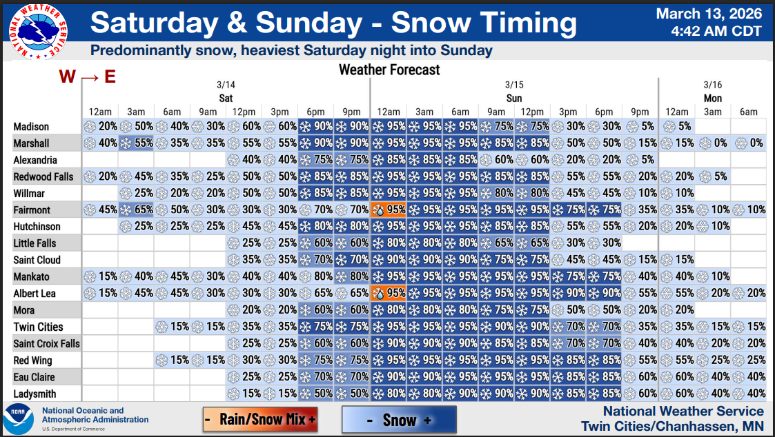
Some areas, the Twin Cities National Weather Service is reporting, could see that 18-20 inches of snowfall in 24 hours mark. That would match, at least, the heavy parts of the 24-hour snowfall in 1991. The 28 inches total – the record of 1991 – is probably safe.

Here’s the rundown:

Snow will begin to fall Saturday in the area, with a line running from St. Cloud east to Forest Lake on south. Snowfall below that gradient will, most likely, hit double-digits. One lucky band is looking to drop 18-20 inches – though that may be for our friends down by Hastings and into Wisconsin.

Closer to home, expect snowfall above 6 inches to be a near certainty. Wright County has a better than 50/50 chance at a foot or more of snow, according to the NWS.

And then, Sunday, the winds will blow, making travel “nearly impossible.” So stock up on those supplies Friday night and/or Saturday before 6 p.m.

WINTER STORM WARNING

Issued By

Minneapolis – MN, US, National Weather Service

Affected Area

Sherburne, Stearns, Wright, Anoka, Carver, Hennepin, Ramsey, and Washington Counties

Description

…WINTER STORM WARNING IN EFFECT FROM 7 PM SATURDAY TO 7 AM CDT MONDAY… WHAT…Heavy snow expected. Total snow accumulations between 10 and 18 inches. Winds gusting as high as 40 mph. WHERE…Sherburne, Stearns, Wright, Anoka, Carver, Hennepin, Ramsey, and Washington Counties. WHEN…From 7 PM Saturday to 7 AM CDT Monday. IMPACTS…Travel could be very difficult to impossible. Widespread blowing snow could significantly reduce visibility. The hazardous conditions will impact the Monday morning commute. PRECAUTIONARY/PREPAREDNESS ACTIONS… If you must travel, keep an extra flashlight, food, and water in your vehicle in case of an emergency. Call 5 1 1 or visit 511mn.org for road conditions.

More Information

…POWERFUL WINTER STORM ON TRACK TO BRING EXTREME SNOW ACCUMULATIONS AND GUSTY WINDS… …TRAVEL MAY BECOME IMPOSSIBLE LATE SATURDAY NIGHT AND SUNDAY… .A major winter storm will move across the Upper Midwest late Saturday into Sunday. The first concern is heavy snow, with a broad area of 10 to 16 inches likely, and a narrow swath of 15 to 20 inches Totals across portions of western and central Wisconsin could approach 2 feet. The heaviest snow will fall Saturday evening and overnight, with rates of 2 inches per hour possible. Winds will start out of the northeast at 20 to 30 mph. The second concern is increasing winds on Sunday. Even though the snow will be diminishing on Sunday, northwest winds will increase to 35 to 45 mph. The combination of heavy snow and gusty winds will reduce visibility and create periods of blizzard conditions on Sunday across western and southern Minnesota. Travel is expected to become very difficult or impossible late Saturday night and Sunday. In addition, the amount of water in the snowpack will make it wet and very heavy, leading to the potential for infrastructure damage and a health hazard for those shoveling.
Share on Tumblr

Tagged With: 2026, blizzard, March, storm

Leave a Review or Comment Cancel reply

You must be logged in to post a comment.

Connect with us online

  • Email
  • Facebook
  • Twitter

Subscribe to North Wright County Today

Daily updates with local news from St. Michael, Albertville, Otsego and Hanover
* = required field
Interests (optional)


unsubscribe from list

powered by MailChimp!

Awarded Top 40 Minnesota News Website

  • About Us
  • Contact Us
  • Login

Contribute a post | Submit for Events Calendar

Copyright © 2026 North Wright County Today | Left Margin Media, LLC