• About Us
  • Contact Us
  • Login

North Wright County Today

Local news for St. Michael, Albertville, Otsego and Hanover

  • News
  • Events
  • Schools
  • Business
  • Obituaries
  • Sports
  • Blogs

Warning Issued: Winter Storm Set to Blast Twin Cities, Ice to South

Veterans Day will be a white one in the Wright County area, the National Weather Service Predicts.

November 10, 2020 By Mike Schoemer

Snow, wind and freezing rain are expected today and tomorrow, Nov. 10 and 11, as a large storm front tracks its way across the state of Minnesota.

The STMA and Otsego area can expect anywhere from 4 to 6 inches of snow from Tuesday night into Wednesday morning – an amount that should snarl the Wednesday morning commute. The snowfall should start falling later on Tuesday afternoon and could also have an impact on Tuesday’s drive home.

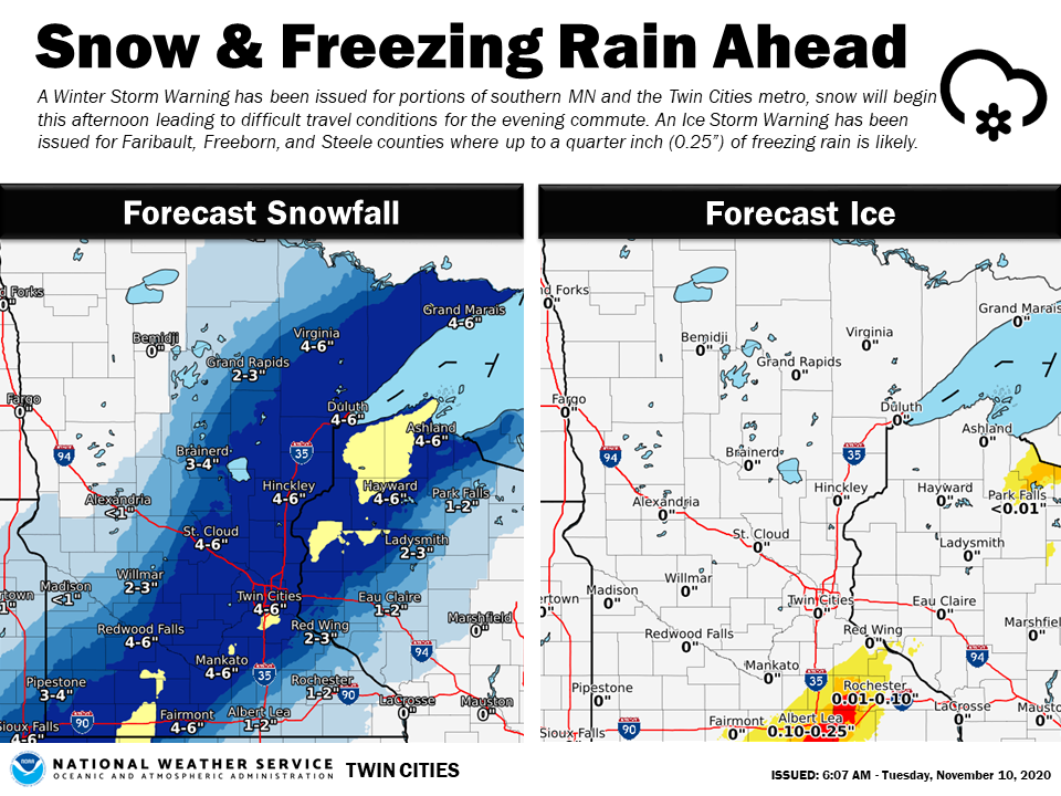
In southeastern Minnesota – near Rochester – ice a is a large concern. The system will drop considerable amounts of freezing rain, and ice coatings one-tenth to one-quarter of an inch thick have been forecast. That will make travel treacherous in those areas and could impact power lines and trees.

Here’s the Winter Storm Warning issued by the National Weather Service Tuesday morning:

WINTER STORM WARNING IN EFFECT UNTIL MIDNIGHT CST TONIGHT… WHAT…Heavy mixed precipitation. Additional snow accumulations of 4 to 6 inches and ice accumulations of a light glaze. WHERE…Sherburne, Isanti, Wright and McLeod Counties. WHEN…Until midnight CST tonight. IMPACTS…Plan on slippery road conditions. The hazardous conditions could impact the evening commute. PRECAUTIONARY/PREPAREDNESS ACTIONS… If you must travel, keep an extra flashlight, food, and water in your vehicle in case of an emergency. The latest road conditions for the state you are calling from can be obtained by calling 5 1 1. Road conditions can also be found at 511mn.org for Minnesota or 511wi.gov for Wisconsin.

More Information

…ICE STORM ACROSS PARTS OF SOUTH CENTRAL MINNESOTA…WITH A MIX OF FREEZING RAIN AND SNOW ACROSS EASTERN MINNESOTA AND WESTERN WISCONSIN… …SEVERAL INCHES OF ACCUMULATING SNOW NOW EXPECTED ACROSS WESTERN MINNESOTA… .A complex system is taking aim at the region, bringing a myriad of weather impacts through the late evening hours. Freezing rain is expected across extreme southern Minnesota where up to one quarter inch of ice may accumulate along with a slushy inch of snow. Farther north, snow will turn to freezing rain for a time across eastern Minnesota and western Wisconsin, then turn to all snow again this evening. Ice accumulation of a tenth to two tenths are possible, in addition to 3 to 6 inches of snow. All snow is expected across western Minnesota where 3 to 7 inches are now forecast. An Ice Storm Warning remains in effect for Freeborn, Steele and Faribault Counties until 6 PM this evening. A Winter Storm Warning is in effect from the rest of south central Minnesota to northwest Wisconsin through this evening, including the Twin Cities metro. A Winter Weather Advisory is in effect for areas from Red Wing, to Eau Claire, to Ladysmith where some light ice and snow accumulations are likely; and across western Minnesota through the evening where several inches of snow are now expected. Use caution if traveling and monitor further updates to the forecast, as even small shifts in the track could greatly alter the expected impacts.


Share on Tumblr

Tagged With: snow, Veterans Day, winter storm warning

Connect with us online

  • Email
  • Facebook
  • Twitter

Subscribe to North Wright County Today

Daily updates with local news from St. Michael, Albertville, Otsego and Hanover
* = required field
Interests (optional)


unsubscribe from list

powered by MailChimp!

Awarded Top 40 Minnesota News Website

  • About Us
  • Contact Us
  • Login

Contribute a post | Submit for Events Calendar

Copyright © 2025 North Wright County Today | Left Margin Media, LLC