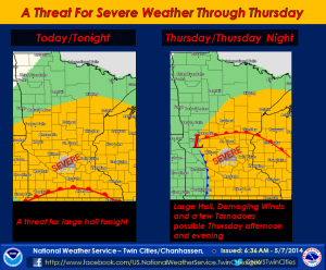
A sweeping storm system is taking shape out of the Eastern Rocky Mountains and Western Plains and headed for the Twin Cities region, with an arrival time of Wednesday night.
The good news is the system is being fed by warm air, so temperatures tomorrow will be the highest we’ve seen in 2014, with a few 80s popping up on the thermometer.
However, prior to that, an initial wave of thunderstorms with the possiblity for some large hail hits the region tonight, according to the National Weather Service in Chanhassen.
There’s a 30 to 40 percent chance (dependent on where you live in Wright County) tonight for the area, but storms are almost a certainty for Thursday, where the chance of rain is now forecast at 80 percent.
Storms will roll through in the afternoon on Thursday, May 8, and linger into Thursday evening, according to the forecast.
Stay tuned to North Wright County Today for more information on this possibility of severe weather tonight and tomorrow.
