Fall, we hardly knew ya.
Since August and September felt like an extended summer, it seems as though the leaves just dropped and the frost just moved in. However, the fact is, it’s mid-November, and that means Friday’s forecast shouldn’t come as a complete shock.
Yes, you guessed it, snow.
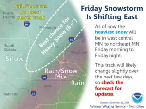
The National Weather Service in the Twin Cities metro has said snowfall – and measurable snow at that – is all but certain for Wright County and points west and north. St. Cloud could see up to 6 inches of slushy, wet snow by Saturday morning as the system rolls through Friday into Saturday.
Closer to home, the latest forecasts call for anywhere from 1 to 5 inches for Wright County, with heavier snowfall out toward Monticello and Clearwater. The storm is shifting east, so higher snowfall could be forecast later this week. Some of northern Minnesota, particularly resort areas like Brainerd and Walker, could see double-digit snowfalls to kick off the season.
The weather will remain colder – but more seasonable. Temps after Saturday will top out in the 40s to mid-40s by early next week, which are average for November. That’s still enough for this new snow to turn into water fairly soon.
Here’s the rundown:
“Pleasant fall weather will hold across the region through Thursday with temperatures well above normal. Thereafter, a low pressure storm system will move northeast across Minnesota and Wisconsin from Friday into Saturday. Confidence is increasing on the likelihood of accumulating snow on the backside of this system, especially to the west and north of the Twin Cities. It’s too early for exact amounts with the storm still 4 days away, but much colder weather, wind and some snow is on the way from Friday into Saturday.”

The National Weather Service forecast for Friday/Saturday and through the weekend.