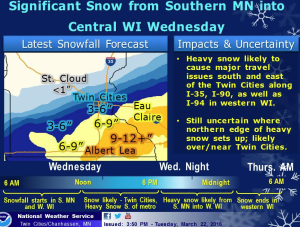
While Monday might have been our first meteorological day of spring, Old Man Winter is nosing his way back into the Twin Cities area, including Wright County, with a winter storm expected to hit the region Wednesday afternoon.
The National Weather Service in Chanhassen has issued a Winter Storm Watch for much of the Twin Cities, including areas just east and south of the North Wright County Today area. Meanwhile, a Winter Storm Warning is shaping up for areas further south, including Dakota County, Red Wing, Rochester and into northern Iowa and eastern Wisconsin.
 While Wright County remains to the north and west of the storm track, the NWS has emphasised that the track of the storm is uncertain, and could shift northward if currents from the Gulf Coast push it out of Iowa and the low pressure system centers over Minnesota. That would bring more moisture into the Wright County area.
However, it seems now that the forecast is for the low pressure center to stay closer to the Iowa border, meaning Wright County would remain fairly dry.
Travel, however, into the Twin Cities and the southern suburbs would be rough for commuters on Wednesday afternoon and Thursday morning if this storm drops the expected 4 to 8 inches of snow on areas like Bloomington, Eagan and Eden Prairie.
Here’s the rundown from the National Weather Service:
WINTER STORM WATCH REMAINS IN EFFECT FROM WEDNESDAY MORNING THROUGH THURSDAY MORNING…
* TIMING… WEDNESDAY MORNING UNTIL THURSDAY MORNING.
* MAIN IMPACT… 6 TO 8 INCHES OF SNOW POSSIBLE.
* OTHER IMPACTS… BLOWING AND DRIFTING SNOW MAY OCCUR WEDNESDAY AFTERNOON AND WEDNESDAY NIGHT.
PRECAUTIONARY/PREPAREDNESS ACTIONS…
A WINTER STORM WATCH MEANS THERE IS A POTENTIAL FOR SIGNIFICANT SNOW… SLEET… OR ICE ACCUMULATIONS THAT MAY IMPACT TRAVEL. CONTINUE TO MONITOR THE LATEST FORECASTS.
More Information
… DANGEROUS WINTER STORM WEDNESDAY AND WEDNESDAY NIGHT…
.A POTENT WINTER STORM WILL MOVE THROUGH THE REGION WEDNESDAY AND WEDNESDAY NIGHT. ALTHOUGH CONFIDENCE IS HIGH ON HEAVY SNOW ACCUMULATION ACROSS SOUTHERN MINNESOTA INTO WEST CENTRAL WISCONSIN… THERE REMAINS SOME UNCERTAINTY ON HOW FAR NORTH THE HEAVY SNOW WILL REACH. THEREFORE… A WINTER STORM WATCH REMAINS IN EFFECT FOR THE TWIN CITIES AND NEW RICHMOND AREAS OF WEST CENTRAL WISCONSIN ON SOUTHWEST THROUGH REDWOOD FALLS AND NEW ULM FOR WEDNESDAY AND WEDNESDAY NIGHT. WITH CONFIDENCE HIGHER FOR HEAVY SNOW ACROSS SOUTHERN MINNESOTA AND ADJOINING AREAS OF WEST CENTRAL WISCONSIN… A WINTER STORM WARNING HAS BEEN ISSUED. THE WARNING AREA IS ALONG AND SOUTH OF A LINE FROM ST JAMES THROUGH RED WING TO CORNELL IN WEST CENTRAL WISCONSIN.
THE PRECIPITATION SHOULD BEGIN AS RAIN EARLY WEDNESDAY MORNING… BUT QUICKLY TRANSITION TO MODERATE TO HEAVY SNOW BY MID MORNING ACROSS SOUTHERN MINNESOTA AND DURING THE AFTERNOON ACROSS ADJOINING AREAS OF WEST CENTRAL WISCONSIN. THE SNOW WILL CONTINUE THROUGH MUCH OF WEDNESDAY NIGHT. IN ADDITION… WIND GUSTS OVER 30 MPH WILL LIKELY LEAD TO SOME BLOWING AND DRIFTING SNOW WEDNESDAY AFTERNOON AND WEDNESDAY NIGHT. SIGNIFICANT IMPACTS TO TRAVEL ARE LIKELY DURING THIS TIME… ESPECIALLY ALONG THE I-90 CORRIDOR AND ALONG I-35 IN SOUTHERN MINNESOTA… .AND ALONG I-94 IN WEST CENTRAL WISCONSIN. IF THE HEAVIER SNOW REACHES INTO THE TWIN CITIES WEDNESDAY AFTERNOON… THE EVENING COMMUTE WILL BE SEVERELY IMPACTED AS WELL. TOTAL SNOW ACCUMULATION BY THURSDAY MORNING IS EXPECTED TO RANGE FROM 6 TO 12 INCHES IN THE WARNING AREA.
March 23rd Snowstorm BriefingThis short video provides some insight into the snowstorm Wednesday and Wednesday night. The main takeaway is there will be a very sharp snowfall gradient across Minnesota and Wisconsin but confidence is low with where it will set up. Confidence is high, however, that 6-12+ inches will fall within the band of heavy snow.
Posted by US National Weather Service Twin Cities Minnesota on Tuesday, March 22, 2016