Don’t expect another one for the record books this winter.
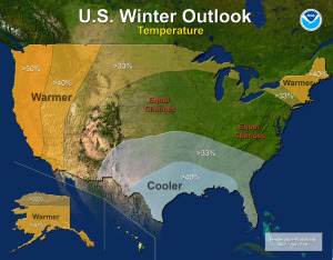
The National Oceanic and Atmospheric Administration, NOAA, released a winter prediction this week that shows near “normal” temperatures and snowfall should be on tap for the Upper Midwest, particularly Minnesota, when winter kicks in a few all-too-short weeks from now.
Actually, information is sketchy for the Wright County area, but what NOAA’s prediction center is not predicting for the area might be just as important as what they are predicting for the rest of the United States.
Last year, heading into the 2013-2014 winter, NOAA predicted cold blasts and higher-than-average snowfall for the Twin Cities and surrounding area, a forecast that came to fruition (though snowfall was only up slightly).
This year, no such forecast is in the cards for the area. Minnesota has an equal chance of going warmer or colder than normal this season, which means the average is, more than likely, going to prevail.
“Last year’s winter was exceptionally cold and snowy across most of the United States, east of the Rockies. A repeat of this extreme pattern is unlikely this year, although the Outlook does favor below-average temperatures in the south-central and southeastern states,” NOAA reports.
If things shift a bit eastward, Minnesota could see an El Ninò type of winter – with above average temperatures.
Here’s NOAA’s report:
Below average temperatures are favored in parts of the south-central and southeastern United States, while above-average temperatures are most likely in the western U.S., Alaska, Hawaii and New England, according to the U.S. Winter Outlook, issued today by NOAA’s Climate Prediction Center.
While drought may improve in some portions of the U.S. this winter, California’s record-setting drought will likely persist or intensify in large parts of the state. Nearly 60 percent of California is suffering from exceptional drought – the worst category – with 2013 being the driest year on record. Also, 2012 and 2013 rank in the top 10 of California’s warmest years on record, and 2014 is shaping up to be California’s warmest year on record. Winter is the wet season in California, so mountainous snowfall will prove crucial for drought recovery. Drought is expected to improve in California’s southern and northwestern regions, but improvement is not expected until December or January.
El Niño, an ocean-atmospheric phenomenon in the Tropical Pacific that affects global weather patterns, may still develop this winter. Climate Prediction Center forecasters announced on Oct. 9 that the ocean and atmospheric coupling necessary to declare an El Niño has not yet happened, so they continued the El Niño Watch with a 67 percent chance of development by the end of the year. While strong El Niño episodes often pull more moisture into California over the winter months, this El Niño is expected to be weak, offering little help.
The Precipitation Outlook favors above-average precipitation across the southern tier, from the southern half of California, across the Southwest, South-central, and Gulf Coast states, Florida, and along the eastern seaboard to Maine. Above-average precipitation also is favored in southern Alaska and the Alaskan panhandle. Below-average precipitation is favored in Hawaii, the Pacific Northwest and the Midwest.
Last year’s winter was exceptionally cold and snowy across most of the United States, east of the Rockies. A repeat of this extreme pattern is unlikely this year, although the Outlook does favor below-average temperatures in the south-central and southeastern states.
In addition, the Temperature Outlook favors warmer-than-average temperatures in the Western U.S., extending from the west coast through most of the inter-mountain west and across the U.S.-Canadian border through New York and New England, as well as Alaska and Hawaii.
The rest of the country falls into the “equal chance” category, meaning that there is not a strong enough climate signal for these areas to make a prediction, so they have an equal chance for above-, near-, or below-normal temperatures and/or precipitation.
This seasonal outlook does not project where and when snowstorms may hit or provide total seasonal snowfall accumulations. Snow forecasts are dependent upon the strength and track of winter storms, which are generally not predictable more than a week in advance.
