 A Winter Storm Watch is in effect now for areas as close at Sherburne County and as far away as Valley City, North Dakota, as a”clipper system” takes aim at northern Minnesota and much of eastern North Dakota.
“The more you travel west on Interstate 94 or [US] Highway 10, the more you’re going to be heading into the teeth of this particular system,” a spokesman for the National Weather Service, Grand Forks, said Monday.
Here’s the rundown from the USNWS:
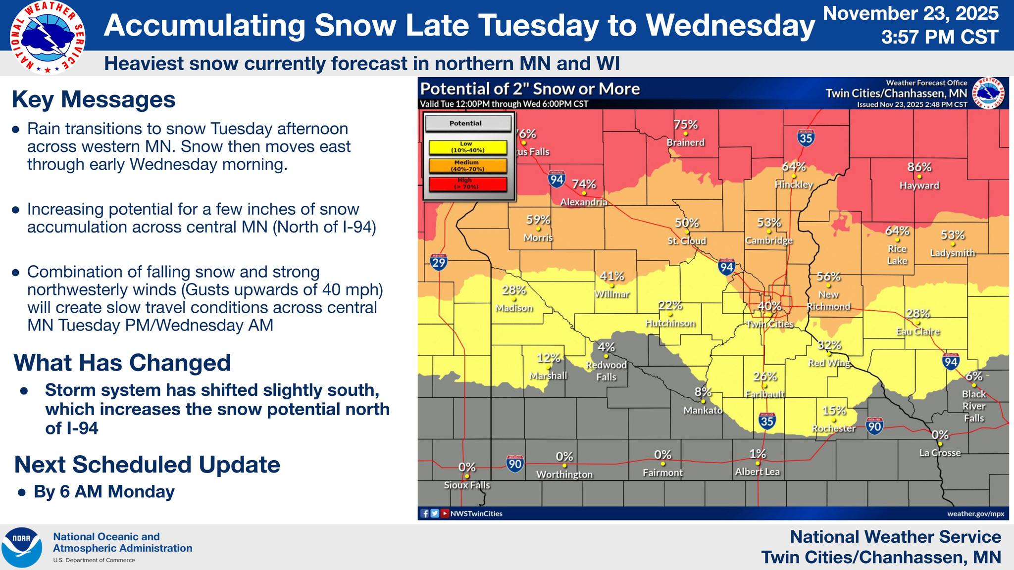
A storm system bringing rain early Tuesday will eventually transition to snow by Tuesday evening as colder air arrives. Currently, the best chance for several inches is north of Morris and Mora, Minnesota. Blowing snow may also occur from strong winds. A Winter Storm Watch is in effect.
RAIN WILL TRANSITION TO SNOW TUESDAY PM, WITH
ACCUMULATING SNOW FALLING THROUGH WEDNESDAY MORNING. WINDS
ALONGSIDE FALLING SNOW WILL LEAD TO REDUCED VISIBILITY DUE TO
BLOWING
SNOW...

.A potent upper level wave will move across the area on Tuesday, with
rain initially becoming snow as the lower atmosphere cools underneath
strengthening forcing for ascent. Rain early on will transition to
snow generally from west to east as the atmosphere cools, becoming
all snow by Tuesday evening. Snow rates could exceed 0.5 inches per
hour at times leading to quick accumulations favoring central
Minnesota.

Winds will increase as the system moves through, with gusts as high
as 35-40mph late Tuesday into early Wednesday leading to reduced
visibility and blowing snow.

MNZ043>045-049-050-241945-
/O.NEW.KMPX.WS.A.0006.251125T2100Z-251126T1800Z/
Morrison-Mille Lacs-Kanabec-Stearns-Benton-
Including the cities of Sauk Rapids, Little Falls, Princeton, St
Cloud, and Mora
142 AM CST Mon Nov 24 2025

...WINTER STORM WATCH IN EFFECT FROM TUESDAY AFTERNOON THROUGH
WEDNESDAY MORNING...

* WHAT...Heavy snow possible. Total snow accumulations between 2 and
  4 inches possible. Winds could gust as high as 40 mph.

* WHERE...Benton, Morrison, Stearns, Kanabec, and Mille Lacs
  Counties.

* WHEN...From Tuesday afternoon through Wednesday morning.

* IMPACTS...Plan on slippery road conditions. The hazardous
  conditions could impact the Tuesday evening and Wednesday morning
  commutes.