UPDATED (3:20 p.m. Friday, March 31)
It’s “common” for a local FM radio host to use a turn of phrase to talk about how he likes his teams – “Biblically Bad or Historically Good.”
If he’s talking about the winter of 2022-2023, one could probably see it either way.
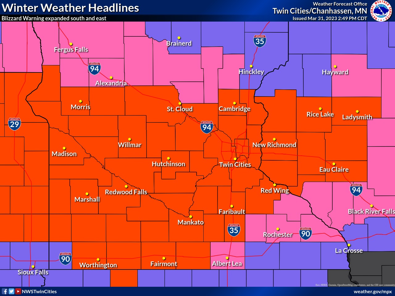
This winter has been historically good for snow lovers, a trend that will continue Friday night as the Wright County area braces for a rare Blizzard Warning. The latest installment in this Historic Winter – which should wind up near the Top 4 in terms of snowfall amounts and the quantity of storm systems according to the National Weather Service – is set to descend on the area from the Dakotas around 5 p.m. this afternoon.
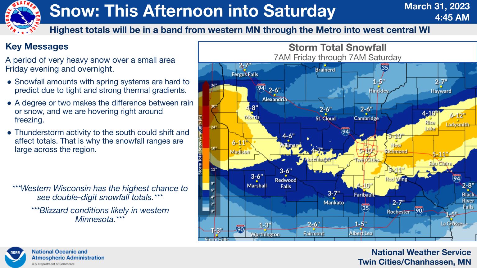
After that – the impacts are anyone’s guess. Rain? Check. Ice? Probably. Another 3 to 5 inches of snowfall? At least. All before 8 a.m. on Saturday, April 1. Toss in 40 to 50 mph wind gusts and you have blizzard conditions for Wright County tonight after 11 p.m.
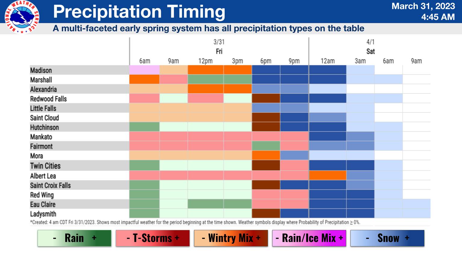
The system will arrive with rain and thunderstorms – with the rain at times being quite heavy, impacting the evening commute. As the temps drop in the region, that rain will quickly turn to wet, sticky snow – falling at nearly 1 inch per hour. It all wraps up around sunrise Saturday morning, or shortly after.
Here’s the gist from the National Weather Service in Chanhassen:
BLIZZARD WARNING EXPANDED EASTWARD TO INCLUDE THE TWIN CITIES
METRO AND WESTERN WISCONSIN...
...SNOWFALL RATES OF 1 TO 2 INCHES PER HOUR ARE EXPECTED FOR
SEVERAL HOURS WITH WIND GUSTS OF 40 TO 50 MPH...

.Widespread precipitation will develop late this afternoon and
transition to heavy snow from northwest to southeast this evening.
The snow could be very heavy at times with hourly rates of 1 to
2.5 inches per hour. Strong north winds will develop with the
heavy snow to produce whiteout conditions over a wide swath from
west central and southwest Minnesota to west central Wisconsin.
The worst conditions are expected between 9 PM and 4 AM, with
snow and strong winds tapering off toward early Saturday morning.

Total snowfall amounts will range from 5 to 10 inches from west
central and southwest Minnesota to west central Wisconsin, with 2
to 5 inches north of Glenwood and St Cloud, and along I-90.
Locally higher amounts are possible if snowfall rates exceed 2
inches per hour.

A Blizzard Warning is in effect for a large area from west central
and southwest Minnesota to west central Wisconsin. A Winter Storm
Warning remains in effect north and south of the Blizzard Warning.

MNZ051>053-059>063-066>070-075-WIZ014-015-023-010515-
/O.UPG.KMPX.WS.W.0008.230401T0000Z-230401T1200Z/
/O.EXB.KMPX.BZ.W.0003.230401T0200Z-230401T1200Z/
Sherburne-Isanti-Chisago-Wright-Hennepin-Anoka-Ramsey-Washington-
McLeod-Sibley-Carver-Scott-Dakota-Nicollet-Polk-Barron-St. Croix-
Including the cities of Elk River, Cambridge, Center City,
Monticello, Minneapolis, Blaine, St Paul, Stillwater, Hutchinson,
Gaylord, Chanhassen, Chaska, Victoria, Shakopee, Hastings,
St Peter, Osceola, Rice Lake, and Hudson
217 PM CDT Fri Mar 31 2023

...BLIZZARD WARNING IN EFFECT FROM 9 PM THIS EVENING TO 7 AM CDT
SATURDAY...

* WHAT...Blizzard conditions expected. Total snow accumulations of
  5 to 10 inches, with locally heavier amounts possible. Winds
  gusting as high as 50 mph.

* WHERE...Portions of central, east central and south central
  Minnesota and northwest and west central Wisconsin.

* WHEN...From 9 PM this evening to 7 AM CDT Saturday.

* IMPACTS...Travel could be very difficult. Widespread blowing
  snow could significantly reduce visibility. Gusty winds could
  bring down tree branches.

PRECAUTIONARY/PREPAREDNESS ACTIONS...

Travel should be restricted to emergencies only. If you must
travel, have a winter survival kit with you. If you get stranded,
stay with your vehicle.

The latest road conditions for the state you are calling from can
be obtained by calling 5 1 1. Road conditions can also be found
at 511mn.org for Minnesota or 511wi.gov for Wisconsin.

&&

$$
Hazardous Weather Outlook
Hazardous Weather Outlook
National Weather Service Twin Cities/Chanhassen MN
252 PM CDT Fri Mar 31 2023

MNZ047>049-051>070-073>078-082>085-091-092-WIZ014>016-023>028-
011945-
Stevens-Pope-Stearns-Sherburne-Isanti-Chisago-Lac Qui Parle-Swift-
Chippewa-Kandiyohi-Meeker-Wright-Hennepin-Anoka-Ramsey-Washington-
Yellow Medicine-Renville-McLeod-Sibley-Carver-Scott-Dakota-
Redwood-Brown-Nicollet-Le Sueur-Rice-Goodhue-Watonwan-Blue Earth-
Waseca-Steele-Martin-Faribault-Polk-Barron-Rusk-St. Croix-Pierce-
Dunn-Pepin-Eau Claire-
252 PM CDT Fri Mar 31 2023

This Hazardous Weather Outlook is for portions of central and
southern Minnesota, and west central Wisconsin.

.DAY ONE...Tonight.

A Blizzard Warning is in effect tonight for several hours of heavy
snow and strong winds, leading to whiteout conditions. Please
refer to the Winter Weather Message for more information.

There is a chance of thunderstorms through early evening. Some
storms could contain hail.

.DAYS TWO THROUGH SEVEN...Saturday through Thursday.

A large storm system is likely to impact the Upper Midwest
Tuesday and Wednesday, bringing a mixture of precipitation types
to the area.