A winter “event” the National Weather Service is calling a “two wave” storm is taking aim at the Wright County and Twin Cities areas, and some forecasters are expecting nearly two feet of snow to hit the region over the next three and a half days.
Snowfall is expected to begin, unfortunately, prior to the Tuesday afternoon commute, with about 3 to 5 inches expected to land Tuesday evening. It’s Wednesday that looks like a complete “white out,” with double digit snowfall amounts expected for much of Central and Southern Minnesota. A foot would not be unexpected on Wednesday, Feb. 22, alone.
For reference, the Cities area averages 6 inches of snow each February.
Wednesday’s snow “dump” would be followed by more snowfall through Thursday morning, and then extremely cold temperatures and “feels-like” temperatures, impacted by high north winds throughout Thursday. The low Thursday night will be 10 to 15 below zero, with winds making it feel like 20 to 30 below zero in Wright County.
Here’s the Winter Storm Warning Statement form the National Weather Service:
MAJOR WINTER STORM TUESDAY THROUGH THURSDAY...

.A major winter storm will bring significant travel impacts
across the region. Most locations can expect to see at least a
foot of snow by the time it ends Thursday night. The worst
conditions will be Wednesday evening through Thursday, as heavy
snow combines with northeast wind gusts of 30 to 40 mph, with
some areas in western Minnesota seeing gusts near 50 mph. This
will lead to significant drifting snow, and whiteout conditions
in open areas.

A Winter Storm Watch remains in effect for portions of central and
southern Minnesota and west central Wisconsin where impacts will
be lesser with the initial snow band Tuesday evening into
Wednesday morning. Additional accumulating snow will arrive with
the main storm Wednesday afternoon that will require an upgrade
of this Winter Storm Watch.

A Winter Storm Warning is now in effect for portions of western
and southern Minnesota and most of the Twin Cities Metro. Forecast
confidence is high that 4 to 7 inches of snow will fall Tuesday
PM into Wednesday AM with the initial round of snow.

The snow will lighten up Wednesday morning, but then widespread
heavy snow will develop later on Wednesday afternoon as the main
storm arrives. This main storm is expected to bring near an
additional foot of snow to most locations, with higher amounts
possible across south-central Minnesota and western Wisconsin.
Areas in western and southern Minnesota may see blizzard
conditions as well.

MNZ054>058-064-065-073-074-082-210915-
/O.UPG.KMPX.WS.A.0003.230221T1800Z-230223T1800Z/
/O.NEW.KMPX.WS.W.0004.230221T1800Z-230223T1800Z/
Lac Qui Parle-Swift-Chippewa-Kandiyohi-Meeker-Yellow Medicine-
Renville-Redwood-Brown-Watonwan-
Including the cities of Madison, Benson, Montevideo, Willmar,
Litchfield, Granite Falls, Olivia, Redwood Falls, New Ulm,
and St James
209 PM CST Mon Feb 20 2023

...WINTER STORM WARNING IN EFFECT FROM NOON TUESDAY TO NOON CST
THURSDAY...

* WHAT...Heavy snow expected. Total snow accumulations of 16 to
  22 inches. Winds gusting as high as 50 mph.

* WHERE...Portions of central, south central, southwest and west
  central Minnesota.

* WHEN...From noon Tuesday to noon CST Thursday.

* IMPACTS...Travel could be very difficult to impossible.
  Widespread blowing snow could significantly reduce visibility.
  The hazardous conditions could impact the morning or evening
  commute. Gusty winds could bring down tree branches. The cold
  wind chills as low as 20 below zero could cause frostbite on
  exposed skin in as little as 30 minutes.


PRECAUTIONARY/PREPAREDNESS ACTIONS...

If you must travel, keep an extra flashlight, food, and water in
your vehicle in case of an emergency.

The latest road conditions for the state you are calling from can
be obtained by calling 5 1 1. Road conditions can also be found
at 511mn.org for Minnesota or 511wi.gov for Wisconsin.

&&

$$
URGENT - WINTER WEATHER MESSAGE National Weather Service Twin Cities/Chanhassen MN 209 PM CST Mon Feb 20 2023 ...MAJOR WINTER STORM TUESDAY THROUGH THURSDAY... .A major winter storm will bring significant travel impacts across the region. Most locations can expect to see at least a foot of snow by the time it ends Thursday night. The worst conditions will be Wednesday evening through Thursday, as heavy snow combines with northeast wind gusts of 30 to 40 mph, with some areas in western Minnesota seeing gusts near 50 mph. This will lead to significant drifting snow, and whiteout conditions in open areas. A Winter Storm Watch remains in effect for portions of central and southern Minnesota and west central Wisconsin where impacts will be lesser with the initial snow band Tuesday evening into Wednesday morning. Additional accumulating snow will arrive with the main storm Wednesday afternoon that will require an upgrade of this Winter Storm Watch.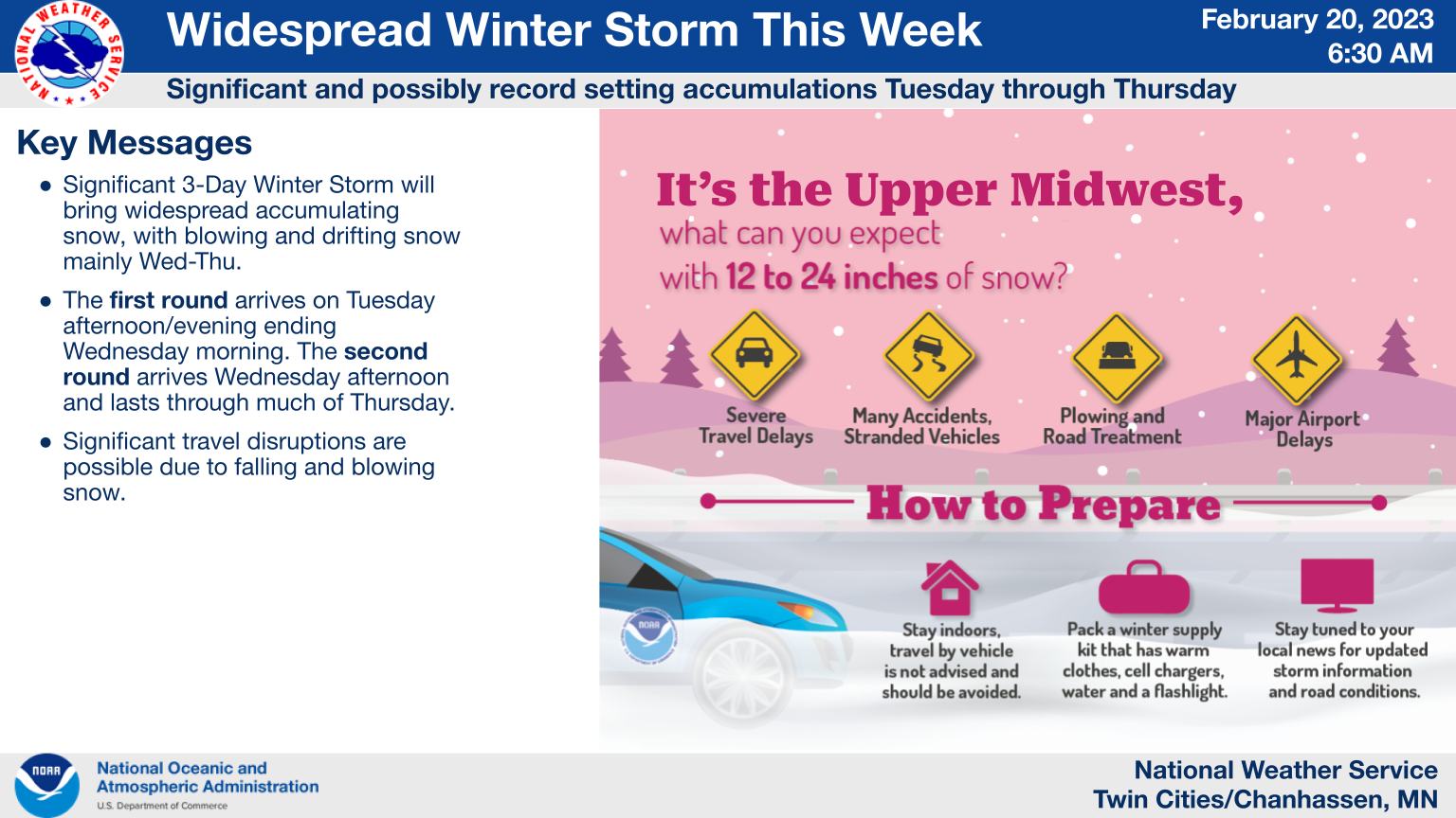
A Winter Storm Warning is now in effect for portions of western and southern Minnesota and most of the Twin Cities Metro. Forecast confidence is high that 4 to 7 inches of snow will fall Tuesday PM into Wednesday AM with the initial round of snow. The snow will lighten up Wednesday morning, but then widespread heavy snow will develop later on Wednesday afternoon as the main storm arrives. This main storm is expected to bring near an additional foot of snow to most locations, with higher amounts possible across south-central Minnesota and western Wisconsin. Areas in western and southern Minnesota may see blizzard conditions as well. MNZ066-067-075-083-210915- /O.UPG.KMPX.WS.A.0003.230221T1800Z-230223T1800Z/ /O.NEW.KMPX.WS.W.0004.230221T2100Z-230224T0000Z/ McLeod-Sibley-Nicollet-Blue Earth- Including the cities of Hutchinson, Gaylord, St Peter, and Mankato 209 PM CST Mon Feb 20 2023 ...WINTER STORM WARNING IN EFFECT FROM 3 PM TUESDAY TO 6 PM CST THURSDAY... * WHAT...Heavy snow expected. Total snow accumulations of 16 to 22 inches. Winds gusting as high as 45 mph. * WHERE...McLeod, Sibley, Nicollet and Blue Earth Counties. * WHEN...From 3 PM Tuesday to 6 PM CST Thursday. * IMPACTS...Travel could be very difficult to impossible. Areas of blowing snow could significantly reduce visibility. The hazardous conditions could impact the morning or evening commute. Gusty winds could bring down tree branches. The cold wind chills as low as 15 below zero could result in hypothermia if precautions are not taken. PRECAUTIONARY/PREPAREDNESS ACTIONS... If you must travel, keep an extra flashlight, food, and water in your vehicle in case of an emergency. The latest road conditions for the state you are calling from can be obtained by calling 5 1 1. Road conditions can also be found at 511mn.org for Minnesota or 511wi.gov for Wisconsin. && $$
URGENT - WINTER WEATHER MESSAGE
National Weather Service Twin Cities/Chanhassen MN
209 PM CST Mon Feb 20 2023

...MAJOR WINTER STORM TUESDAY THROUGH THURSDAY...

A major winter storm will bring significant travel impacts
across the region. Most locations can expect to see at least a
foot of snow by the time it ends Thursday night. The worst
conditions will be Wednesday evening through Thursday, as heavy
snow combines with northeast wind gusts of 30 to 40 mph, with
some areas in western Minnesota seeing gusts near 50 mph. This
will lead to significant drifting snow, and whiteout conditions
in open areas.

A Winter Storm Watch remains in effect for portions of central and
southern Minnesota and west central Wisconsin where impacts will
be lesser with the initial snow band Tuesday evening into
Wednesday morning. Additional accumulating snow will arrive with
the main storm Wednesday afternoon that will require an upgrade
of this Winter Storm Watch.

A Winter Storm Warning is now in effect for portions of western
and southern Minnesota and most of the Twin Cities Metro. Forecast
confidence is high that 4 to 7 inches of snow will fall Tuesday
PM into Wednesday AM with the initial round of snow.

The snow will lighten up Wednesday morning, but then widespread
heavy snow will develop later on Wednesday afternoon as the main
storm arrives. This main storm is expected to bring near an
additional foot of snow to most locations, with higher amounts
possible across south-central Minnesota and western Wisconsin.
Areas in western and southern Minnesota may see blizzard
conditions as well.

Wright-Hennepin-Ramsey-Washington-Carver-Scott-Dakota-Le Sueur-
Rice-Goodhue-Waseca-Steele-
Including the cities of Monticello, Minneapolis, St Paul,
Stillwater, Chanhassen, Chaska, Victoria, Shakopee, Hastings,
Le Sueur, Faribault, Red Wing, Waseca, and Owatonna
209 PM CST Mon Feb 20 2023

...WINTER STORM WARNING IN EFFECT FROM 3 PM TUESDAY TO 6 PM CST
THURSDAY...

* WHAT...Heavy snow expected. Total snow accumulations of 18 to
  22 inches. Winds gusting as high as 45 mph.

* WHERE...Portions of central, east central, south central and
  southeast Minnesota.

* WHEN...From 3 PM Tuesday to 6 PM CST Thursday.

* IMPACTS...Travel could be very difficult to impossible. Areas
  of blowing snow could significantly reduce visibility. The
  hazardous conditions could impact the morning or evening
  commute.


PRECAUTIONARY/PREPAREDNESS ACTIONS...

If you must travel, keep an extra flashlight, food, and water in
your vehicle in case of an emergency.

The latest road conditions for the state you are calling from can
be obtained by calling 5 1 1. Road conditions can also be found
at 511mn.org for Minnesota or 511wi.gov for Wisconsin.