A week after more than a foot of snow fell on the NWCT area, another wintry Wednesday is in store for St. Michael, Albertville, Otsego, Hanover and beyond.
A mixed snow/mist precipitation will swing into the area Tuesday (today), then turn to all snow overnight. While just 2 t0 5 inches of new snow is expected, it will be enough to make the morning commute “adventurous,” something that has become somewhat routine in the Twin Cities area after huge snowfall amounts last week and ice earlier this week.
Agencies are encouraging drivers to have a plan, particularly if you’re headed northwest of the Twin Cities. A Winter Storm Warning is in place for areas like Moorhead, Fargo (N.D.), Barnesville and other areas of North Dakota and extreme western Minnesota.
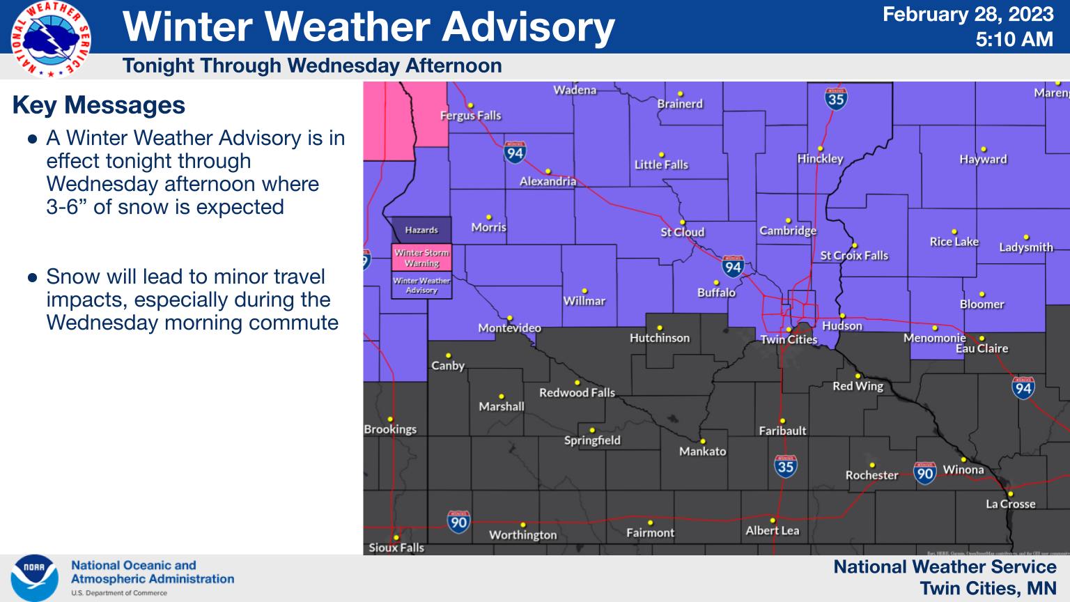
Here are the advisories from the National Weather Service in the Twin Cities:
...SNOW EXPECTED THIS EVENING THROUGH WEDNESDAY AFTERNOON...

.Light snow will develop over western Minnesota this evening and
spread eastward over central and eastern Minnesota through western
Wisconsin Tuesday night into Wednesday, ending Wednesday
afternoon. Most locations within this band of snow will see 2 to
6 inches, with local amounts as high as 7 inches possible near
Alexandria and Long Prairie. Areas most likely to receive in
excess of 3 inches of snow include those . A Winter Weather
Advisory continues to be in effect for locations along and north of a line
from Montevideo to the Twin Cities in Minnesota, to Eau Claire in
Wisconsin.

MNZ053-058>063-010315-
/O.CON.KMPX.WW.Y.0011.230301T0300Z-230301T2100Z/
Chisago-Meeker-Wright-Hennepin-Anoka-Ramsey-Washington-
Including the cities of Center City, Litchfield, Monticello,
Minneapolis, Blaine, St Paul, and Stillwater
108 PM CST Tue Feb 28 2023

...WINTER WEATHER ADVISORY REMAINS IN EFFECT FROM 9 PM THIS
EVENING TO 3 PM CST WEDNESDAY...

* WHAT...Snow expected. Total snow accumulations of 1 to 3
  inches.

* WHERE...Portions of central and east central Minnesota.

* WHEN...From 9 PM this evening to 3 PM CST Wednesday.

* IMPACTS...Plan on slippery road conditions. The hazardous
  conditions could impact the morning commute.

PRECAUTIONARY/PREPAREDNESS ACTIONS...

Slow down and use caution while traveling.

The latest road conditions for the state you are calling from can
be obtained by calling 5 1 1. Road conditions can also be found
at 511mn.org for Minnesota or 511wi.gov for Wisconsin.

&&

$$
Hazardous Weather Outlook
Hazardous Weather Outlook
National Weather Service Twin Cities/Chanhassen MN
347 AM CST Tue Feb 28 2023

MNZ041>045-047>063-WIZ014>016-023-025-027-011000-
Douglas-Todd-Morrison-Mille Lacs-Kanabec-Stevens-Pope-Stearns-
Benton-Sherburne-Isanti-Chisago-Lac Qui Parle-Swift-Chippewa-
Kandiyohi-Meeker-Wright-Hennepin-Anoka-Ramsey-Washington-Polk-
Barron-Rusk-St. Croix-Dunn-
347 AM CST Tue Feb 28 2023

This Hazardous Weather Outlook is for portions of central
Minnesota...east central Minnesota...west central Minnesota...
northwest Wisconsin and west central Wisconsin.

.DAY ONE...Today and Tonight.

Light snow will develop this evening and continue through tonight.
Snow accumulations of 2 to 5 inches are likely. A Winter Weather
Advisory is in effect this evening through tonight. Please refer
to the Winter Weather Message for additional details.

.DAYS TWO THROUGH SEVEN...Wednesday through Monday.

Light snow will diminish during the day Wednesday. Snow
accumulations of 1 to 2 inches are likely. A Winter Weather
Advisory is in effect through Wednesday afternoon. Please refer to
the Winter Weather Message for additional details.

.SPOTTER INFORMATION STATEMENT...

Spotters and snowfall observers are encouraged to report snowfall
amounts to the National Weather Service.