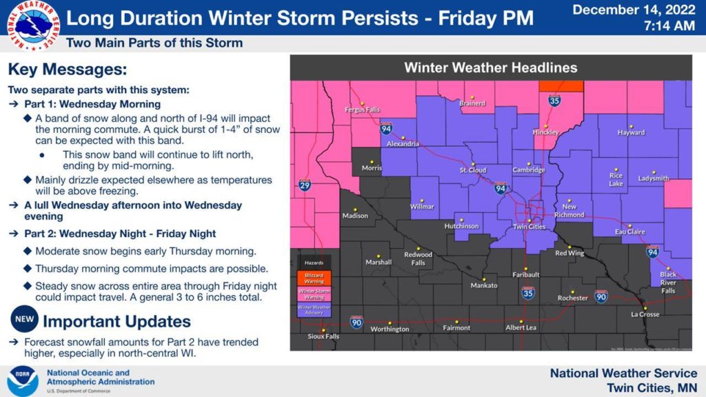
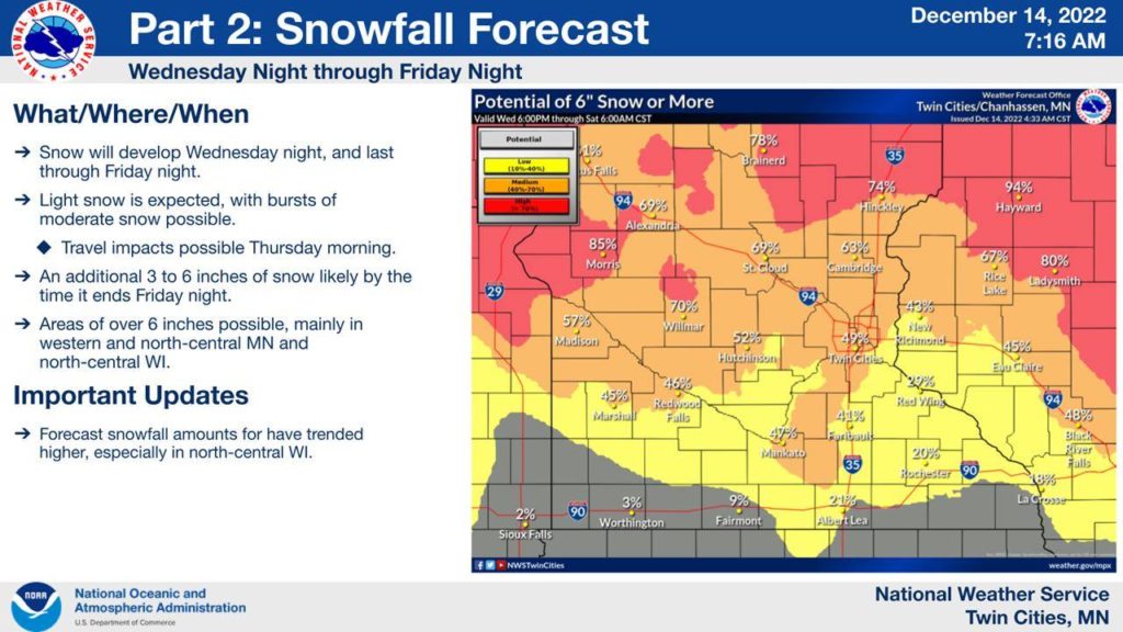
The first wave was a sloppy, slushy mess. But the second wave of this week’s series of winter storms is shaping up to bring dangerous, blizzard conditions to Wright County and the Twin Cities Wednesday night through Thursday, Dec. 15.
The National Weather Service has issued a Winter Storm Warning for the area, handing down the forecast warning at about 2 p.m. on Wednesday, Dec. 14. High winds – with gusts over 40 mph – and prolonged periods of snow will create blowing, drifting and even whiteout conditions Thursday morning and throughout the day.
Here’s the warning:
URGENT - WINTER WEATHER MESSAGE
National Weather Service Twin Cities/Chanhassen MN
147 PM CST Wed Dec 14 2022

MNZ041-042-047>049-054>059-064-151015-
/O.EXB.KMPX.WS.W.0006.221215T0900Z-221216T0300Z/
Douglas-Todd-Stevens-Pope-Stearns-Lac Qui Parle-Swift-Chippewa-
Kandiyohi-Meeker-Wright-Yellow Medicine-
Including the cities of Alexandria, Long Prairie, Morris,
Glenwood, St Cloud, Madison, Benson, Montevideo, Willmar,
Litchfield, Monticello, and Granite Falls
147 PM CST Wed Dec 14 2022

...WINTER STORM WARNING IN EFFECT FROM 3 AM TO 9 PM CST
THURSDAY...

* WHAT...Heavy snow expected. Precipitation may start as rain, but
  will quickly change to snow. Total snow accumulations of 4 to 7
  inches. Winds gusting as high as 40 mph Thursday afternoon and
  evening.

* WHERE...Portions of central and west central Minnesota.

* WHEN...From 3 AM to 9 PM CST Thursday.

* IMPACTS...Plan on slippery road conditions. Patchy blowing
  snow could significantly reduce visibility. The hazardous
  conditions could impact the morning or evening commute.

PRECAUTIONARY/PREPAREDNESS ACTIONS...

If you must travel, keep an extra flashlight, food, and water in
your vehicle in case of an emergency.

The latest road conditions for the state you are calling from can
be obtained by calling 5 1 1. Road conditions can also be found
at 511mn.org for Minnesota or 511wi.gov for Wisconsin.

&&

$$
URGENT - WINTER WEATHER MESSAGE
National Weather Service Twin Cities/Chanhassen MN
147 PM CST Wed Dec 14 2022

MNZ060>062-070-151015-
/O.UPG.KMPX.WS.A.0005.221215T0600Z-221216T0000Z/
/O.EXA.KMPX.WS.W.0006.221215T0600Z-221216T0000Z/
Hennepin-Anoka-Ramsey-Dakota-
Including the cities of Minneapolis, Blaine, St Paul,
and Hastings
147 PM CST Wed Dec 14 2022

...WINTER STORM WARNING IN EFFECT FROM MIDNIGHT TONIGHT TO 6 PM
CST THURSDAY...

* WHAT...Heavy snow expected. Precipitation may start as rain
  later this evening, but will quickly change to snow overnight.
  Total snow accumulations of 4 to 7 inches.

* WHERE...Hennepin, Anoka, Ramsey and Dakota Counties.

* WHEN...From midnight tonight to 6 PM CST Thursday.

* IMPACTS...Plan on slippery road conditions. The hazardous
  conditions could impact the morning or evening commute.

PRECAUTIONARY/PREPAREDNESS ACTIONS...

If you must travel, keep an extra flashlight, food, and water in
your vehicle in case of an emergency.

The latest road conditions for the state you are calling from can
be obtained by calling 5 1 1. Road conditions can also be found
at 511mn.org for Minnesota or 511wi.gov for Wisconsin.

&&

$$