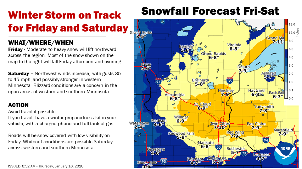
The first winter storm of the new decade is taking aim at the Twin Cities area, and Wright County residents can expect at least 6 inches of new snow by Friday night, followed by howling winds and rough driving conditions on Saturday, Jan. 18.
“There’s no doubt the Twin Cities area will see significant snowfall amounts. How much remains to be seen, but it could reach up to a foot in some areas, depending on the storm track,” a spokesperson from the National Weather Service Twin Cities said Thursday, Jan. 16. “The storm will move from the west to the east, with much of the moisture in the system coming from the southwest. We’re expecting that to be followed by blizzard-like conditions around Willmar and Mankato and points to the north and west on Saturday, so this weekend will be tough for travelling. If you can, stay home.”
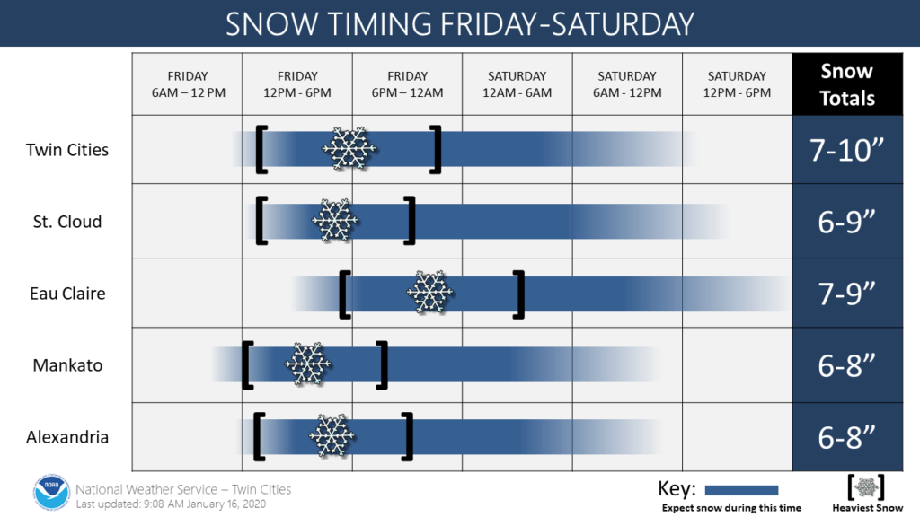
Snowfall should begin shortly after the lunch hour on Friday, forecasters said, and continue through mid-day on Saturday. Snowfall will be heavy at the storm’s outset, particularly Saturday afternoon, with rates of up to an inch of snow per hour.
Blizzard warnings are in effect for areas such as Fergus Falls and Fargo, North Dakota, where less snow is expected by higher winds – near 45 mph – will hit Friday night.
 Here’s the rundown from the Winter Storm Warning issued by the NWS Thursday morning:
WINTER STORM WARNING HEAVY SNOW ON FRIDAY FOLLOWED BY STRONG
WIND AND BLOWING SNOW ON SATURDAY WITH BLIZZARD CONDITIONS
POSSIBLE IN WESTERN AND SOUTHERN MINNESOTA...

Moderate to heavy snow will develop across western Minnesota
Friday morning and move through eastern Minnesota into western
Wisconsin early Friday afternoon and continue through Friday
evening. Most of the snow will fall late Friday morning into
Friday evening. Currently, 5 to 9 inches of snow is expected
across much of central and southern Minnesota and western
Wisconsin.

Snow will taper off Friday night, but on Saturday northwest winds
will increase and lead to significant blowing and drifting snow.
In addition, falling temperatures will lead to icy roads. Farther
west, blizzard conditions are possible in open areas of western
into southern Minnesota. If the forecast winds of 40 to 45 mph
remain on track, an upgrade to a blizzard warning is likely for
Saturday across western and southern Minnesota.

This storm will impact travel. Moderate to heavy snow will lead to
snow-covered roads on Friday. Strong winds and falling
temperatures will lead to blowing snow and drifting on Saturday.

MNZ043-044-050>052-059>063-068>070-078-WIZ023-024-026-170145-
/O.UPG.KMPX.WS.A.0001.200117T1800Z-200119T0000Z/
/O.NEW.KMPX.WS.W.0001.200117T1800Z-200119T0000Z/
Morrison-Mille Lacs-Benton-Sherburne-Isanti-Wright-Hennepin-Anoka-
Ramsey-Washington-Carver-Scott-Dakota-Goodhue-St. Croix-Pierce-
Pepin-
Including the cities of Little Falls, Princeton, Foley,
Elk River, Cambridge, Monticello, Minneapolis, Blaine, St Paul,
Stillwater, Chaska, Shakopee, Hastings, Red Wing, Hudson,
River Falls, Prescott, and Durand
1131 AM CST Thu Jan 16 2020

...WINTER STORM WARNING IN EFFECT FROM NOON FRIDAY TO 6 PM CST
SATURDAY...

* WHAT...Heavy snow expected on Friday. Total snow accumulations
  of 6 to 9 inches. Northwest winds gusting as high as 40 mph on
  Saturday with significant blowing and drifting.

* WHERE...Portions of west central Wisconsin and central, east
  central and southeast Minnesota.

* WHEN...From noon Friday to 6 PM CST Saturday.

* IMPACTS...Travel could be very difficult. Patchy blowing snow
  could significantly reduce visibility. The hazardous conditions
  could impact the evening commute.

PRECAUTIONARY/PREPAREDNESS ACTIONS...

If you must travel, keep an extra flashlight, food, and water in
your vehicle in case of an emergency.

The latest road conditions for the state you are calling from can
be obtained by calling 5 1 1.