Winter may make its formal entrance just in time for the Thanksgiving holiday week, according to a Winter Storm Warning issued by the National Weather Service – Twin Cities in Chanhassen.
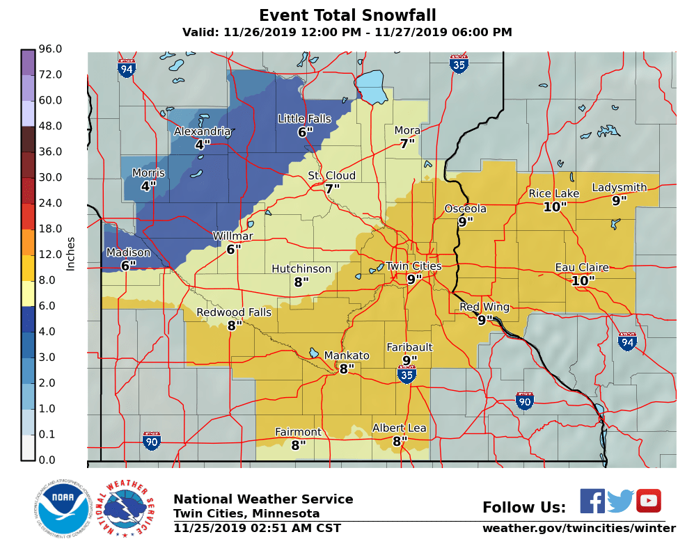
The Wright County area could see up to 6 inches of snowfall between noon on Tuesday, Nov. 26 and 6 p.m. on Wednesday, Nov. 27 if the storm track holds. That will make for some tough sledding for holiday travelers, especially for those who are headed south or southwest.
“The track really seems to come up from Nebraska and South Dakota, through the southwestern portion of Minnesota and into the Twin Cities. The metro should see quite a bit of snow,” an NWS spokesperson said. “In some places, it could be record-setting snowfall.”
 Here’s the Winter Storm Warning, updated on Monday afternoon:
A Winter Storm Warning has been issued for portions of southwest,
south central, and east central Minnesota, and all of west central
Wisconsin starting late Tuesday afternoon, and continuing through
Wednesday morning. The warning includes areas along the Buffalo
Ridge in west central Minnesota, and areas southeast of a line
from Redwood Falls, to Hutchinson, Clearwater, Princeton and Rush
City in Minnesota. Snowfall totals of 6 or more inches are
likely in the warned area, with locally higher amounts possible.
In addition, gusty northeast winds Tuesday night will shift to
the northwest Wednesday, resulting in areas of blowing snow.
Travel could be significantly impacted through at least Wednesday
morning.

Due to some uncertainties in the snowfall amounts, a Winter Storm
Watch remains in effect Tuesday afternoon through Wednesday
morning north of the Minnesota River from Granite Falls to St.
Cloud and Milaca. Snowfall totals of 6 or more inches are still
possible in the watch area.

Snow will develop across southern Minnesota late Tuesday
afternoon and spread northeastward across southern, and east
central Minnesota, and into west central Wisconsin Tuesday night.
The snow will be heavy at times. Snow will end from west to east
Wednesday morning, but blowing snow could continue into the
afternoon.

MNZ051>053-059>063-WIZ014>016-023>028-260430-
/O.UPG.KMPX.WS.A.0012.191127T0300Z-191127T1800Z/
/O.NEW.KMPX.WS.W.0011.191127T0300Z-191127T1800Z/
Sherburne-Isanti-Chisago-Wright-Hennepin-Anoka-Ramsey-Washington-
Polk-Barron-Rusk-St. Croix-Pierce-Dunn-Pepin-Chippewa-Eau Claire-
Including the cities of Elk River, Cambridge, Center City,
Monticello, Minneapolis, Blaine, St Paul, Stillwater, Osceola,
Rice Lake, Ladysmith, Hudson, River Falls, Prescott, Menomonie,
Durand, Chippewa Falls, and Eau Claire
221 PM CST Mon Nov 25 2019

...WINTER STORM WARNING IN EFFECT FROM 9 PM TUESDAY TO NOON CST
WEDNESDAY...

* WHAT...Heavy snow expected. Total snow accumulations of 4 to 7
  inches, with locally higher amounts. Winds gusting as high as
  35 mph.

* WHERE...Portions of northwest and west central Wisconsin and
  central and east central Minnesota.

* WHEN...From 9 PM Tuesday to noon CST Wednesday.

* IMPACTS...Travel could be very difficult. Patchy blowing snow
  could significantly reduce visibility. The hazardous
  conditions could impact the morning commute.

PRECAUTIONARY/PREPAREDNESS ACTIONS...

If you must travel, keep an extra flashlight, food, and water in
your vehicle in case of an emergency.

The latest road conditions for the state you are calling from can
be obtained by calling 5 1 1.