A strong storm system is expected to sweep through the Wright County area Wednesday night through Friday morning with heavy precipitation, high winds and the potential for overland flooding in low-lying areas.
But the biggest question is – how much of it will come in the form of snow?
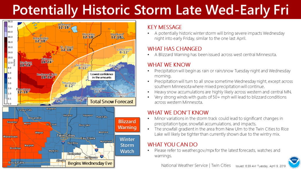
Forecasters are grappling with that question, as the system could drop up to 20 inches of snow in Western Minnesota. A Winter Storm Watch and Blizzard Watch have both been issued in areas like Mankato, Willmar and points west.
To the east – heavier rains are expected, dropping snowfall amounts, but still creating a soupy mess with rain, ice and some heavy, spring snow.
“The rain/snow line is, for now, forecast to be south and east of the [Twin Cities] Metro,” a spokesperson from the National Weather Service in Chanhassen, Minnesota, said. “That means the potential for up to a foot of snow in the Twin Cities, especially to the west of Minneapolis.”
Here’s the statement from NWS: A potentially historic April storm will arrive late Wednesday, bringing a variety of precipitation types, strong wind gusts in excess of 50 mph, and heavy snow totals. Blizzard conditions are expected across western Minnesota with nearly impossible travel conditions by Thursday.
The snowfall gradient near the metro may end up tighter than (originally forecast) due the chance for a more prolonged wintry mix. In addition, the map shows total snowfall amounts added up for each six-hour period – the amount on the ground after the storm could be less due to varying precip types.
Here’s the Winter Storm Watch, issued Tuesday by the NWS:
WINTER STORM WATCH NOW IN EFFECT FROM WEDNESDAY EVENING THROUGH FRIDAY MORNING… * WHAT…BLIZZARD CONDITIONS POSSIBLE. TOTAL SNOW ACCUMULATIONS OF 12 TO 18 INCHES POSSIBLE. WINDS COULD GUST AS HIGH AS 50 MPH. * WHERE…WRIGHT, BENTON AND SHERBURNE COUNTIES. * WHEN…FROM WEDNESDAY EVENING THROUGH FRIDAY MORNING. * ADDITIONAL DETAILS…TRAVEL COULD BE VERY DIFFICULT TO IMPOSSIBLE. AREAS OF BLOWING SNOW COULD SIGNIFICANTLY REDUCE VISIBILITY. THE HAZARDOUS CONDITIONS COULD IMPACT THE MORNING OR EVENING COMMUTE. GUSTY WINDS COULD BRING DOWN TREE BRANCHES. PRECAUTIONARY/PREPAREDNESS ACTIONS… A WINTER STORM WATCH FOR BLIZZARD CONDITIONS MEANS THERE IS A POTENTIAL FOR FALLING AND/OR BLOWING SNOW WITH STRONG WINDS AND EXTREMELY POOR VISIBILITIES. THIS CAN LEAD TO WHITEOUT CONDITIONS AND MAKE TRAVEL VERY DANGEROUS. &&
More Information
…ANOTHER POTENTIALLY HISTORIC MID APRIL WINTER STORM WEDNESDAY NIGHT THROUGH THURSDAY NIGHT… .A BLIZZARD WARNING IS IN EFFECT NORTHWEST OF A LINE FROM REDWOOD FALLS TO SAINT CLOUD. A WINTER STORM WATCH IS IN EFFECT FOR MOST OF THE REST OF CENTRAL AND SOUTHERN MINNESOTA AND WESTERN WISCONSIN. A POTENTIALLY HISTORIC WINTER STORM IS EXPECTED STARTING WEDNESDAY EVENING LASTING INTO EARLY FRIDAY MORNING. CONFIDENCE IS HIGH THAT A BAND OF HEAVY SNOW WILL REACH CENTRAL AND WESTERN MINNESOTA WEDNESDAY EVENING AND CONTINUE THROUGH THURSDAY, TAPERING OFF IN INTENSITY GRADUALLY THURSDAY NIGHT. SNOWFALL RATES OF 1 TO 2 INCHES PER HOUR WILL BE POSSIBLE AT TIMES. PERIODS OF MIXED PRECIPITATION IN THE FORM OF RAIN, SNOW, AND SLEET ARE EXPECTED ALONG AND SOUTH OF A LINE FROM NEW ULM, TO THE TWIN CITIES METRO, TO RICE LAKE, WISCONSIN. THERE IS STILL CONSIDERABLE UNCERTAINTY WHERE THIS TRANSITION ZONE WILL SET UP. A TIGHTER GRADIENT IN SNOWFALL TOTALS THAN CURRENTLY FORECAST SHOULD BE EXPECTED ALONG THIS ZONE. WINDS WILL INCREASE WEDNESDAY NIGHT WITH GUSTS OF 45 TO 55 MPH BY THURSDAY. THIS WILL LEAD TO WIDESPREAD BLOWING AND DRIFTING SNOW AND BLIZZARD CONDITIONS ACROSS WEST CENTRAL MINNESOTA. TRAVEL COULD BECOME NEARLY IMPOSSIBLE IN THIS AREA BY THURSDAY.