By now, the looks of exasperation are gone, and you’re looking at the forecast with a knowing nod.
More snow – up to 12 inches in some places – is tracking with a huge front that will hit Minnesota (virtually all of it), and how much snow we get depends on timing and temperature, as it does with so many spring storms.
 It’s not that April snow is uncommon – we see it a lot in Minnesota. It’s that there has been so much of it this spring. Consistently snow pack has come, gone and possibly come again around these parts. But St. Cloud was measuring 8 inches of snowpack as recently as Monday, April 9, and the Granite City could see more than a foot of snow accumulation this weekend.
The National Weather Service HAS issued a Winter Storm WATCH for the Wright County Area:
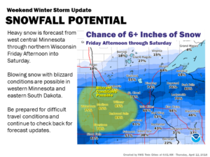
ONFIDENCE INCREASING ON A SIGNIFICANT WINTER STORM FRIDAY
AFTERNOON THROUGH SATURDAY EVENING...

.Confidence has increased that a significant winter storm will
develop Friday afternoon, and continue into Saturday evening. All
precipitation types, strong winds, and blizzard conditions will be
possible in this winter storm. A Winter Storm Watch remains in
effect for Friday afternoon and Saturday for much of central and
southern Minnesota and west central Wisconsin.

Rain and thunderstorms are expected to develop late tonight, and
persist for much of the day Friday as temperatures remain in the
mid 30s in central Minnesota to the lower 40s along the Minnesota
Iowa border. Colder air will begin to move into central Minnesota
Friday afternoon and evening, changing the precipitation to snow
across central and western Minnesota. In addition to the heavy
snow, strong gusty winds of 40 to 50 mph will bring the
possibility of blizzard conditions to west central Minnesota. The
best chance for whiteouts will be late Friday night across west
central Minnesota. The rain will turn to a wintry mix of freezing
rain, or freezing drizzle, sleet, and snow across south central
and east central Minnesota, and west central Wisconsin Friday
evening, before changing to all snow Saturday morning.

Total snow accumulations of 8 to 16 inches are possible across
central and west central Minnesota, with totals tapering off to 3
or 6 inches across south central Minnesota, and west central
Wisconsin. Total ice and sleet accumulations of one to two tenths
of an inch are possible across the southern third of Minnesota
into west central Wisconsin.

MNZ051>059-061-064-065-073-WIZ014>016-130015-
/O.CON.KMPX.WS.A.0009.180414T0000Z-180415T0600Z/
Sherburne-Isanti-Chisago-Lac Qui Parle-Swift-Chippewa-Kandiyohi-
Meeker-Wright-Anoka-Yellow Medicine-Renville-Redwood-Polk-Barron-
Rusk-
Including the cities of Elk River, Cambridge, Center City,
Madison, Benson, Montevideo, Willmar, Litchfield, Monticello,
Blaine, Granite Falls, Olivia, Redwood Falls, Osceola, Rice Lake,
and Ladysmith
1109 AM CDT Thu Apr 12 2018

...WINTER STORM WATCH REMAINS IN EFFECT FROM FRIDAY EVENING
THROUGH LATE SATURDAY NIGHT...

* WHAT...Heavy mixed precipitation possible. Total snow
  accumulations of 8 to 12 inches, with localized amounts up to
  16 inches, and ice accumulations of around one tenth are
  possible.

* WHERE...Portions of northwest Wisconsin and central, east
  central, southwest and west central Minnesota.

* WHEN...From Friday evening through late Saturday night.

* ADDITIONAL DETAILS...Travel could be very difficult to
  impossible. Tree branches could fall. Winds gusting as high as
  45 mph could cause areas of blowing and drifting snow.

PRECAUTIONARY/PREPAREDNESS ACTIONS...

A Winter Storm Watch means there is potential for significant
snow, sleet or ice accumulations that may impact travel. Continue
to monitor the latest forecasts.