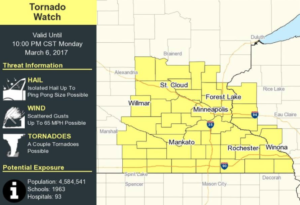
It may or may not be the earliest tornado watch on record, depending on which meteorological group you ask. Either way, it’s happening: Wright County is under a Tornado Watch until 10 p.m. Monday, March 6 as a rare batch of late winter thunderstorms marches from the plains of Nebraska into the Upper Midwest states.
Two huge low pressure systems – one wreaking havoc in northern North Dakota (closing schools in Minot and other communities), the other coming up from the south with loads of moisture creating thunderstorms and high winds – are converging on Minnesota. The result? A lot of moving air.
Though the Tornado Watch runs through this evening, that might be the easy part. Tomorrow’s forecast – 20 degrees cooler than today with a high probability of wind gusts over 50 mph. That’s not good news for trees that were thawed out by 60 degree temperatures the last two days.
Experts are recommending big rigs – semis with trailers – be prepared to hit the rest stops of the world tomorrow, as high wind advisories have been issued for much of Minnesota.
 Here’s the watch information, and the high wind info, as well:
TORNADO WATCH 63 IS IN EFFECT UNTIL 1000 PM CST FOR THE
 FOLLOWING LOCATIONS

MNC003-009-013-015-019-025-033-037-039-043-045-047-049-053-055-
059-063-065-067-079-085-091-093-095-097-099-103-109-123-127-129-
131-139-141-143-145-147-153-157-161-163-165-169-171-070400-
/O.NEW.KWNS.TO.A.0063.170306T2045Z-170307T0400Z/

MN
.    MINNESOTA COUNTIES INCLUDED ARE

ANOKA                BENTON              BLUE EARTH
BROWN                CARVER              CHISAGO
COTTONWOOD           DAKOTA              DODGE
FARIBAULT            FILLMORE            FREEBORN
GOODHUE              HENNEPIN            HOUSTON
ISANTI               JACKSON             KANABEC
KANDIYOHI            LE SUEUR            MARTIN
MCLEOD               MEEKER              MILLE LACS
MORRISON             MOWER               NICOLLET
OLMSTED              RAMSEY              REDWOOD
RENVILLE             RICE                SCOTT
SHERBURNE            SIBLEY              STEARNS
STEELE               TODD                WABASHA
WASECA               WASHINGTON          WATONWAN
WINONA               WRIGHT
$$
Wind Advisory
URGENT - WEATHER MESSAGE
National Weather Service Twin Cities/Chanhassen MN
253 PM CST Mon Mar 6 2017

MNZ041>044-048>052-057>063-066>070-076>078-070500-
/O.CON.KMPX.WI.Y.0002.170307T0100Z-170307T1500Z/
/O.CON.KMPX.HW.A.0001.170307T1500Z-170308T0300Z/
Douglas-Todd-Morrison-Mille Lacs-Pope-Stearns-Benton-Sherburne-
Isanti-Kandiyohi-Meeker-Wright-Hennepin-Anoka-Ramsey-Washington-
McLeod-Sibley-Carver-Scott-Dakota-Le Sueur-Rice-Goodhue-
Including the cities of Alexandria, Long Prairie, Little Falls,
Princeton, Glenwood, St Cloud, Foley, Elk River, Cambridge,
Willmar, Litchfield, Monticello, Minneapolis, Blaine, St Paul,
Stillwater, Hutchinson, Gaylord, Chaska, Shakopee, Hastings,
Le Sueur, Faribault, and Red Wing
253 PM CST Mon Mar 6 2017

...WIND ADVISORY REMAINS IN EFFECT FROM 7 PM THIS EVENING TO 9 AM
CST TUESDAY...
...HIGH WIND WATCH REMAINS IN EFFECT FROM TUESDAY MORNING THROUGH
TUESDAY EVENING...

* TIMING/WINDS...A cold front will push through this evening
  with winds becoming southwest and increasing for a time with
  gusts of 45 mph possible. After a relative lull in intensity
  overnight, west winds will increase again Tuesday morning with
  gusts of 60 mph possible through early evening.

* IMPACTS...Tree damage and power outages are possible.
  Unsecured, lighter objects will be blown around. Driving may
  be difficult, particularly on north/south roads.

PRECAUTIONARY/PREPAREDNESS ACTIONS...

A High Wind Watch means there is the potential for a hazardous
high wind event. Sustained winds of at least 40 mph...or gusts of
58 mph or stronger may occur. Continue to monitor the latest
forecasts.

A Wind Advisory means that wind gusts in excess of 45 mph are
expected. Winds this strong can make driving difficult...
especially for high profile vehicles. Use extra caution.
A touchdown of a tornado on March 6 would be the earliest recorded in Minnesota, and one of the few before meteorological spring, which is March 21.