In case you forgot the dates on the calendar, it is only February.
So it shouldn’t be a total surprise, then, that winter is making a triumphant return Thursday and Friday, with significant snowfall now in the forecast for Wright County and, perhaps more significantly, the Twin Cities metropolitan area.
A swath of snow is expected to hit the lower third of the state, with the heaviest snowfall amounts – about 6 to 12 inches of heavy, wet stuff, to fall in the southwestern suburbs (Lakeville, Eagan, Woodbury) of the Twin Cities.
That said, Wright County, particularly the eastern section of the county, could see its biggest snowfall of the 2016-2017 winter.
Here’s the latest from the National Weather Service:
“What could be the strongest winter storm of the season is expected to bring heavy snow to a large area of the Central Plains, to southern and eastern Minnesota and northern Wisconsin. Rain will develop across southern Minnesota Thursday afternoon before changing to heavy snow Thursday night through Friday. Snowfall rates of 1 to 2 inches per hour are likely within the intense snow band, which could persist for several hours.
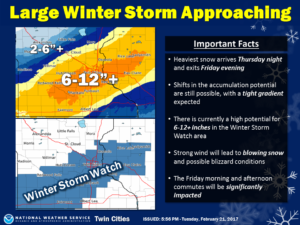 Snow accumulations of 6 to 12 inches are likely from southwest to east central Minnesota and west central Wisconsin, with amounts of over a foot possible. Some shifting in the heaviest snow swath is still possible. A Winter Storm Watch has been issued for the area most likely to receive these amounts, but it could be expanded northwestward in subsequent forecasts. In addition, northeast winds Friday morning becoming north and northwest Friday afternoon will gust as high as 40 mph. Blowing snow will further reduce visibilities. If these winds materialize, blizzard conditions should be expected in open areas.
“Now is the time to continue monitoring forecasts and be prepared for a significant winter storm at the end of the week,” the NWS reports.
Here’s the official Winter Storm Watch:
WINTER STORM WATCH IN EFFECT FROM THURSDAY EVENING THROUGH FRIDAY AFTERNOON… THE NATIONAL WEATHER SERVICE IN TWIN CITIES/CHANHASSEN HAS ISSUED A WINTER STORM WATCH, WHICH IS IN EFFECT FROM THURSDAY EVENING THROUGH FRIDAY AFTERNOON. * TIMING… RAIN WILL TURN TO SNOW THURSDAY EVENING AND CONTINUE THROUGH FRIDAY. * SNOW ACCUMULATIONS… 6 TO 12 INCHES ARE LIKELY, WITH AMOUNTS OF OVER A FOOT POSSIBLE. * WINDS… NORTHEAST TO NORTHWEST 20 TO 30 MPH WITH GUSTS TO 40 MPH RESULTING IN CONSIDERABLE BLOWING SNOW AND POSSIBLE BLIZZARD CONDITIONS. PRECAUTIONARY/PREPAREDNESS ACTIONS… A WINTER STORM WATCH MEANS THERE IS A POTENTIAL FOR SIGNIFICANT SNOW… SLEET… OR ICE ACCUMULATIONS THAT MAY IMPACT TRAVEL. CONTINUE TO MONITOR THE LATEST FORECASTS.
… POWERFUL WINTER STORM TAKING AIM AT THE UPPER MIDWEST THURSDAY NIGHT THROUGH FRIDAY EVENING… BRINGING HEAVY SNOW… STRONG WINDS… AND BLOWING SNOW… .WHAT COULD BE THE STRONGEST WINTER STORM OF THE SEASON IS EXPECTED TO TRACK ACROSS THE PLAINS THURSDAY, TO IOWA THURSDAY NIGHT, AND WISCONSIN BY FRIDAY. RAIN WILL DEVELOP ACROSS SOUTHERN MINNESOTA THURSDAY AFTERNOON AND EARLY EVENING BEFORE CHANGING TO HEAVY SNOW THURSDAY NIGHT THROUGH FRIDAY. SNOWFALL RATES OF 1 TO 2 INCHES PER HOUR ARE LIKELY WITHIN THE INTENSE SNOW BAND, WHICH COULD PERSIST FOR SEVERAL HOURS. SNOW ACCUMULATIONS OF 6 TO 12 INCHES ARE LIKELY FROM SOUTHWEST TO EAST CENTRAL MINNESOTA AND WEST CENTRAL WISCONSIN, WITH AMOUNTS OF OVER A FOOT POSSIBLE. A WINTER STORM WATCH HAS BEEN ISSUED FOR THE AREA MOST LIKELY TO RECEIVE THESE AMOUNTS, BUT IT COULD BE EXPANDED NORTHWARD IN SUBSEQUENT FORECASTS. IN ADDITION, NORTHEAST WINDS FRIDAY MORNING BECOMING NORTH AND NORTHWEST FRIDAY AFTERNOON WILL GUST AS HIGH AS 40 MPH. BLOWING SNOW WILL FURTHER REDUCE VISIBILITIES. IF THESE WINDS MATERIALIZE, BLIZZARD CONDITIONS SHOULD BE EXPECTED IN OPEN AREAS. THE FRIDAY MORNING AND AFTERNOON COMMUTES ARE EXPECTED TO BE SIGNIFICANTLY IMPACTED.