The good news is, there are 40-degree temperatures in the forecast this week.
The bad news? The National Weather Service in the Twin Cities has issued a Winter Weather Advisory for the Wright County area, as a fast-moving storm is expected to dump about a half-foot of snow on the area Sunday night into Monday.
According to the NWS, snow could fall at a rate of more than an inch per hour and up to two inches per hour in some places late Sunday, with snow tapering off, finally, early Monday.
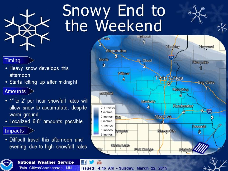 Areas in Wright County could see as much as 8 inches of snow when it’s all said and done on Monday.
Precipitation returns to the forecast Tuesday – as rain. But, snow could return Wednesday early morning and linger into Wednesday daytime. Accumulating snow, the NWS states, is expected for Wednesday.
Fortunately, high 40s are forecast for next weekend, which should help melt away any of those leftover flakes.
Here’s the Winter Weather Advisory for Sunday/Monday, March 22 and 23:
WINTER WEATHER RETURNS WITH A BURST OF HEAVY ACCUMULATING SNOW
THIS AFTERNOON AND EVENING...

.SNOW...POSSIBLY MIXED WITH RAIN...WILL SPREAD INTO CENTRAL AND
EASTERN MINNESOTA LATE THIS MORNING AND INTO WESTERN WISCONSIN BY
EARLY AFTERNOON. THE PRECIPITATION WILL QUICKLY INTENSIFY AFTER
ITS ONSET...AND WILL FALL AS ALL SNOW THROUGH THE EVENING. HEAVY
SNOWFALL RATES OF 1 TO 2 INCHES PER HOUR ARE POSSIBLE. TOTAL SNOW
ACCUMULATIONS OF 3 TO 6 INCHES ARE EXPECTED ALONG AND JUST SOUTH
OF INTERSTATE 94 AND NORTH OF THE MINNESOTA RIVER WHERE A WINTER
WEATHER ADVISORY IS IN EFFECT. THE HIGHEST TOTALS ARE EXPECTED TO
BE CENTERED IN A NARROW BAND JUST WEST AND SOUTH OF THE TWIN
CITIES METRO AREA...FROM NEAR HUTCHINSON AND BELLE
PLAINE...SOUTHEAST TO ZUMBROTA...WHERE ISOLATED TOTALS COULD
EXCEED 6 INCHES.

INCLUDING THE CITIES OF...ST. CLOUD...ELK RIVER...WILLMAR...
LITCHFIELD...MONTICELLO...MINNEAPOLIS...BLAINE...ST. PAUL...
STILLWATER...HUTCHINSON...GAYLORD...CHASKA...SHAKOPEE...
HASTINGS...LE SUEUR...FARIBAULT...RED WING...OWATONNA...HUDSON...
PRESCOTT...DURAND
341 AM CDT SUN MAR 22 2015

...WINTER WEATHER ADVISORY REMAINS IN EFFECT FROM 11 AM THIS
MORNING TO 1 AM CDT MONDAY...

* TIMING: A MIX OF RAIN AND SNOW WILL QUICKLY BECOME MODERATE TO
  HEAVY SNOW BY SUNDAY AFTERNOON. THE SNOW WILL TAPER OFF BY MID
  SUNDAY EVENING.

* SNOWFALL ACCUMULATIONS: 3 TO 6 INCHES. LOCALIZED TOTALS
  EXCEEDING 6 INCHES ARE POSSIBLE.

* IMPACTS: TRAVEL MAY BE DIFFICULT SUNDAY AFTERNOON AND EVENING.

PRECAUTIONARY/PREPAREDNESS ACTIONS...

A WINTER WEATHER ADVISORY FOR SNOW MEANS THAT PERIODS OF SNOW
WILL CAUSE PRIMARILY TRAVEL DIFFICULTIES. BE PREPARED FOR SNOW
COVERED ROADS AND LIMITED VISIBILITIES...AND USE CAUTION WHILE
DRIVING.