When you’re all set to head “over the river and through the woods” for turkey at Grandmother’s house, you might want to give yourself a little extra travel time if you’re leaving Wednesday, Nov. 26.
Count on a couple of things – first, it’s the busiest travel day of the year according to the National Highway Traffic Safety Administration and AAA; second – there’s measurable snow in the forecast for Wednesday.
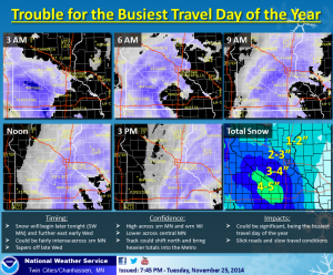
The National Weather Service in Chanhassen has issued a Winter Weather Advisory for much of south central and southeastern Minnesota, but the advisory does reach as far north as Wright County and the NWCToday coverage area.
Snow is expected to fall and accumulate on roads Wednesday sporadically as a storm system sweeps its way along the southern third of the state.
For those heading south and west this holiday, travel could be particularly treacherous tomorrow, as the Interstate 90 corridor could be impacted by as much as 6 inches of new snow.
Here’s the details in the advisory:
SNOW WILL MOVE INTO WEST CENTRAL MINNESOTA LATE TUESDAY EVENING AND
THEN SPREAD SOUTHEAST INTO SOUTH CENTRAL MINNESOTA DURING THE
OVERNIGHT HOURS...AND FINALLY EAST CENTRAL MINNESOTA INCLUDING THE
TWIN CITIES METRO EARLY WEDNESDAY MORNING. THE SNOW WILL CONTINUE
THROUGH THE MORNING ACROSS WEST CENTRAL MINNESOTA BEFORE
ENDING...WHILE THE SNOW WILL CONTINUE FOR MUCH OF THE DAY ACROSS
SOUTH CENTRAL AND EAST CENTRAL MINNESOTA. SNOW ACCUMULATION ACROSS
THE AREA WILL BE IN THE 3 TO 5 INCH RANGE. A WINTER WEATHER
ADVISORY HAS BEEN ISSUED FOR LATE TONIGHT AND WEDNESDAY MORNING
FOR WEST CENTRAL THROUGH SOUTH CENTRAL MINNESOTA...ALONG AND SOUTH
OF A LINE FROM MADISON TO BUFFALO AND ST PAUL. THE ADVISORY
CONTINUES WEDNESDAY AFTERNOON ALONG THE I-35 CORRIDOR FROM ST PAUL
TO ALBERT LEA.

WRIGHT-HENNEPIN-RAMSEY-CARVER-SCOTT-DAKOTA-
INCLUDING THE CITIES OF...MONTICELLO...MINNEAPOLIS...ST. PAUL...
CHASKA...SHAKOPEE...BURNSVILLE

...WINTER WEATHER ADVISORY IN EFFECT FROM 6 AM TO 6 PM CST
WEDNESDAY...

THE NATIONAL WEATHER SERVICE IN TWIN CITIES/CHANHASSEN HAS ISSUED
A WINTER WEATHER ADVISORY FOR SNOW...WHICH IS IN EFFECT FROM 6 AM
TO 6 PM CST WEDNESDAY.

* MAIN IMPACT...TRAVEL MAY BE HAZARDOUS WEDNESDAY. EXPECT THE
  POSSIBILITY OF SIGNIFICANT DELAYS FOR THE BUSIEST TRAVEL DAY OF
  THE YEAR.

* SNOW ACCUMULATION...2 TO 5 INCHES...WITH THE HEAVIEST TOTALS IN
  THE FAR SOUTHWEST TWIN CITIES SUBURBS AND THE LIGHTEST AMOUNTS
  IN THE NORTHERN AND EASTERN TWIN CITIES SUBURBS.

* TIMING...ACCUMULATING SNOW DEVELOPING AROUND 6 AM AND CONTINUING
  THROUGH MID AFTERNOON.

PRECAUTIONARY/PREPAREDNESS ACTIONS...

A WINTER WEATHER ADVISORY FOR SNOW MEANS THAT PERIODS OF SNOW
WILL CAUSE PRIMARILY TRAVEL DIFFICULTIES. BE PREPARED FOR SNOW
COVERED ROADS AND LIMITED VISIBILITIES...AND USE CAUTION WHILE
DRIVING.