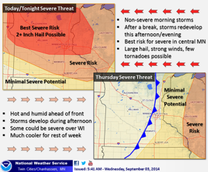
The National Weather Service in Chanhassen is stating Wednesday, Sept. 3 could be a bumpy day for local storms.
The area can expect rainfall throughout much of the morning, with a break coming mid-afternoon. However, Wednesday night storms are expected to fire up again, this time packing a heavier punch than just the occasional lightning strike or rumble of thunder.
According to the NWS:
data coming in shows two distinct focus areas….one in region form Sisseton, SD, east through Alexandria to St Cloud and then southeast toward the Twin Cities. This is for this afternoon-evening and has a higher tornado potential. The northern edge of this more intense action may clip Fergus Falls-Wadena-Elbow Lake….and possibly as far northwest as Wahpeton-Detroit Lakes-Park Rapids. Part 2 is later tonight as a cold front moves in from the west and there is a risk of severe storms over much of North Dakota from this…and in eastern ND threat is after sunset…mostly after midnight.
