Just when you thought it was safe to put away the shovels and snowblowers, another shot of winter will return.
Or, you might just choose not to shovel this one at all. No one would blame any resident for doing that with 70-degree temperatures in the 5-day forecast.
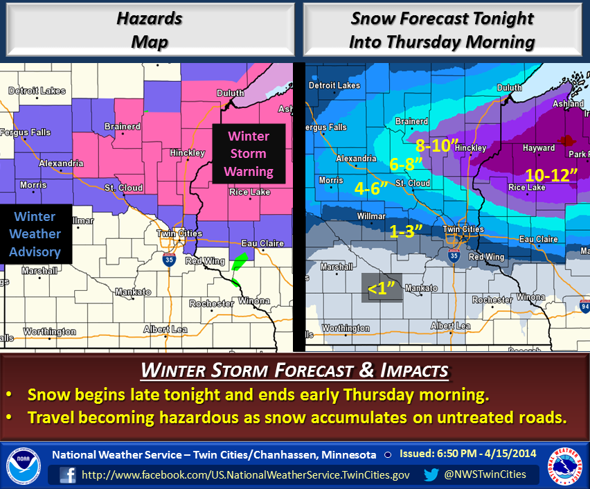
Graphic released by the National Weather Service
Winter is set to make its return to Minnesota and Wisconsin Wednesday night and into Thursday, dropping heavy, wet snow across a band that stretches from St. Cloud in Minnesota to parts of northern Wisconsin.
The heaviest snow is predicted, according to the National Weather Service of the Twin Cities, to fall east of the Twin Cities metro, with Rice Lake and Hayward, WI seeing the worst of the snow.
But Wright County areas, which are not in the Winter Storm Warning issued for north of this area, still could see anywhere of 5 to 8 inches of new snow fall.
That doesn’t mean accumulated amounts will look that deep. According to the NWS, surface temps are above 50 degrees on most paved areas, so roads should look mostly wet until Wednesday and Thursday evening, when the stuff will stick.
Here’s the “Hazardous Weather Statement” issued Tuesday evening:
HAZARDOUS WEATHER OUTLOOK…UPDATED
NATIONAL WEATHER SERVICE TWIN CITIES/CHANHASSEN MN
554 PM CDT TUE APR 15 2014

MNZ041>045-047>070-073>078-082>085-091>093-WIZ014>016-023>028-
161815-
DOUGLAS-TODD-MORRISON-MILLE LACS-KANABEC-STEVENS-POPE-STEARNS-
BENTON-SHERBURNE-ISANTI-CHISAGO-LAC QUI PARLE-SWIFT-CHIPPEWA-
KANDIYOHI-MEEKER-WRIGHT-HENNEPIN-ANOKA-RAMSEY-WASHINGTON-
YELLOW MEDICINE-RENVILLE-MCLEOD-SIBLEY-CARVER-SCOTT-DAKOTA-
REDWOOD-BROWN-NICOLLET-LE SUEUR-RICE-GOODHUE-WATONWAN-BLUE EARTH-
WASECA-STEELE-MARTIN-FARIBAULT-FREEBORN-POLK-BARRON-RUSK-
ST. CROIX-PIERCE-DUNN-PEPIN-EAU CLAIRE-
554 PM CDT TUE APR 15 2014

THIS HAZARDOUS WEATHER OUTLOOK IS FOR PORTIONS OF CENTRAL AND
SOUTHERN MINNESOTA...AND WEST CENTRAL WISCONSIN.

.DAY ONE...TONIGHT

SNOW WILL DEVELOP ACROSS CENTRAL MINNESOTA AFTER MIDNIGHT AND SPREAD
ACROSS WEST CENTRAL WISCONSIN TOWARD DAYBREAK. SNOW AMOUNTS FROM 1
TO 2 INCHES ARE LIKELY.

.DAYS TWO THROUGH SEVEN...WEDNESDAY THROUGH MONDAY

ACCUMULATING SNOW IS LIKELY WEDNESDAY AND WEDNESDAY NIGHT ACROSS
CENTRAL MINNESOTA AND PORTIONS OF WEST CENTRAL WISCONSIN. A WINTER
STORM WARNING IS IN EFFECT FOR AREAS NORTH AND EAST OF ST. CLOUD...
AS WELL AS ALONG HIGHWAY 8 IN WEST CENTRAL WISCONSIN...FOR
ACCUMULATIONS OF 6 INCHES OR MORE. A WINTER WEATHER ADVISORY BORDERS
THE WARNING AREA TO THE WEST AND SOUTH FOR ACCUMULATIONS OF 3 TO 6
INCHES. FARTHER SOUTH WHERE WARMER TEMPERATURES WILL ALLOW FOR A
PERIOD OF RAIN ON WEDNESDAY...INCLUDING WILLMAR THROUGH THE TWIN
CITIES...TO EAU CLAIRE...A SLOPPY 1-3 INCHES OF ACCUMULATION IS
POSSIBLE.